Live screenshots from the Play Store, captured by our snapshot worker. Tap any image to enlarge.
Geoclass is a professional surveying calculator built for engineers (mining, civil, and environmental), surveyors, and GIS technicians. It combines coordinate geometry (COGO), UTM map, coordinate conversion for 592 systems across 55 countries, slope calculations, and area computations, all in a single app.
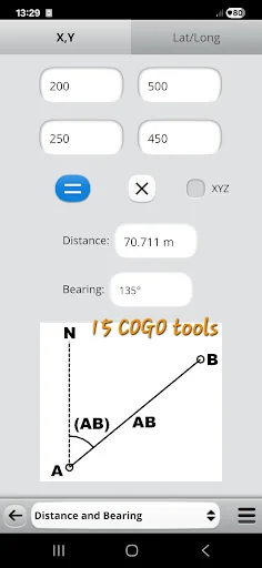
★ 15 COGO CALCULATION TOOLS
• Calculate Coordinate — new point from bearing + distance
• Distance and Bearing — inverse calculation between two points
• Forward Intersection — from two k…
Read full description →
Geoclass is a professional surveying calculator built for engineers (mining, civil, and environmental), surveyors, and GIS technicians. It combines coordinate geometry (COGO), UTM map, coordinate conversion for 592 systems across 55 countries, slope calculations, and area computations, all in a single app.
★ 15 COGO CALCULATION TOOLS
• Calculate Coordinate — new point from bearing + distance
• Distance and Bearing — inverse calculation between two points
• Forward Intersection — from two known points + angles
• Backward Intersection (Resection) — Tienstra's method from 3 known points
• Line-Line Intersection — intersection of two straight lines
• Middle Point — midpoint between two points
• Perpendicular Foot — drop a perpendicular from a point to a line
• Circle by 3 Points — circumscribed circle through three points
• Generate Coordinates — interpolate points along a line
• Interior Angle — angle from three coordinate points
• Bearing from Angles — compute bearings from measured angles
• Angle Converter — Degree ↔ Radian ↔ Grad ↔ Mil
• Helmert Transformation — 2D similarity (4-parameter) transformation
• Horizontal Curve — road/highway curve calculations
• Map Scale — ground distance ↔ map distance
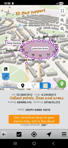
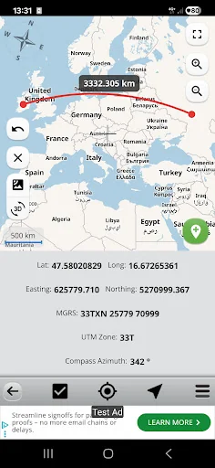
★ INTERACTIVE UTM MAP
• Real-time GPS with Lat/Long, UTM, and MGRS coordinates
• Compass with azimuth angle display
• Add, edit, and manage points, lines, and areas on the map
• Measure distances and navigate to coordinates
• UTM zone grid overlay
• Persistent GeoPackage storage for all map data
★ COORDINATE CONVERTER — 592 SYSTEMS, 55 COUNTRIES
Convert between local Cartesian and geographic coordinate systems for:
Algeria, Australia, Belgium, Brazil, Canada, Chile, Egypt, Ethiopia, Finland, France, Germany, Greece, India, Indonesia, Iran, Iraq, Ireland, Italy, Kenya, Malaysia, Mexico, Morocco, Myanmar, Netherlands, Nigeria, Norway, Pakistan, Peru, Philippines, Poland, Portugal, Russia, Saudi Arabia, Spain, Sweden, Tanzania, Thailand, Turkey, UAE, United Kingdom, USA (state-level), and more.
Powered by the PROJ library — the same engine used by QGIS and ArcGIS.
★ IMPORT & EXPORT
• Import: CSV/TXT, GeoJSON, KML, KMZ
• Export: Text, DXF, GeoJSON, GeoPackage
• GDAL-accelerated import for large spatial datasets
• Full interoperability with QGIS, ArcGIS, Google Earth, and AutoCAD
★ ADDITIONAL TOOLS
• Slope Calculator — from levels, coordinates, or horizontal/vertical distances
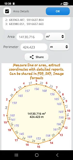
• Area from Coordinates — Shoelace formula with graphical shape display
• LatLong ↔ UTM Converter — WGS84 bidirectional conversion with GPS
• DMS ↔ Decimal degree converter
★ KEY FEATURES
• Configurable units: meters, km, miles, nautical miles, yards, feet, inches
• Angle units: degrees, DMS, DM, grads (gon)
• Adjustable decimal precision for distances and angles
• North-East / East-North coordinate ordering
• RTL language support
• Works offline — all calculations run locally on your device
You can follow news about the app on Facebook Page:
fb.me/surveyingcalculator
The five apps in Maps & Navigation with the closest revenue to Geoclass Surveying Calculator. Click any to see its detail page.
Each forecast combines App Store rating, ratings count, monetisation model, pricing tier, IAP signals and ad-supported flag.
The base estimate is then multiplied by a per-category scaling factor learned from apps with founder-verified MRR.
Every number on this page comes from public APIs and bumetric's own snapshot history.

 Winnipeg Transit RT
 Du Goiás - Motorista
 Mobile Monitoring
 Taxee
Taxee
 Taxi Thắng Lợi Driver