 58
58

BU Score
Solid

Hiking Map Poland


✍️ BU Analytics Review
“
Hiking Map Poland is an iOS app from Mapa Turystyczna sp. z o.o. in the Travel category, currently rated 4.8★ across 97 ratings. Initial signal reads as mixed reviews — supporters praise core features while critics cite stability/value gaps.
Our BU Score puts it at 58 — Solid (established niche player). For a Travel app, that means established niche player.
Track changes month-over-month in the Performance section below — live snapshot history and revenue forecast included.
📊 Performance Tracking LIVE
Loading…
Rating
—
Reviews
—
Forecast Revenue / mo
—
Snapshots tracked
0
since first record
Range:
💰 Forecast Revenue / mo
MODELRevenue forecast computed from BU's 234 trigger model on each snapshot. Calibrated against ground-truth from 58 verified-revenue apps.
🔬Forecast Breakdown — Why This Estimate?Top 4 of 4 triggers
Our ML model uses 200+ signals from public data. These are the most influential for this app:
| Paid app ($0.00)METRIC | +$2,800 | |
| Excellent rating (4.8★)METRIC | +$2,200 | |
| Mature app (9y old)METRIC | +$1,500 | |
| Pre-traction phase (97 ratings)METRIC | −$300 |
METRIC = structural app data · REVIEW = mined from user reviews · ✓ VERIFIED = Stripe-verified anchor (TrustMRR)
📈 Reviews Growth
LIVECumulative review count from first BU snapshot. Each point = a tracked update.
⭐ Rating Trend
LIVEAverage rating evolution. Updates with each new review batch.
🗓️ Snapshot Timeline
HISTORYEach bar shows a tracked update and the metric delta from the previous snapshot.
App Specs
🔐 Own this app? Claim & verify MRR →💾 84 MB🔞 4+📱 iOS 16.0+🔖 v2.0.30🔄 updated 2mo ago🌐 EN, PL📂 Travel💰 Paid🚀 Launched 2016 (9y old)
📝 About this app
Route planning
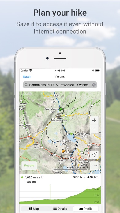
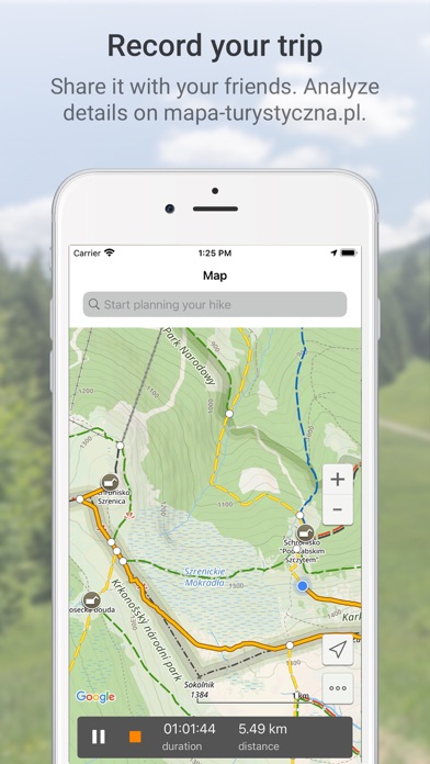
The main functionality is planning routes leading along official hiking trails in the mountains and foothills of Poland. The app finds a route quick and easy, displays it on a map, shows its length, estimated time, detailed course and elevation profile. It also shows your current location.
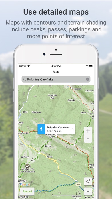
Routes are displayed on detailed Touristic map layer with contours and terrain shading, which contains peaks, passes, parkings and other points of interest. It's also possible to download maps of regions listed further in this description and use them offline.
Tracks recording
Second main functionality is recording tracks. You can then share it with your friends!
Interesting places
The app also displays information about points of interest: photos and opinions taken from the mapa-turystyczna.pl website.
Detailed functionalities:
- planning routes based on given points; points can be chosen from map or found using the search box,
- intelligent search suggestions, considering spots closest to your location and those most popular,
- displaying routes on a map along with their length, estimated time, route details (spots and trails) and elevation profile,
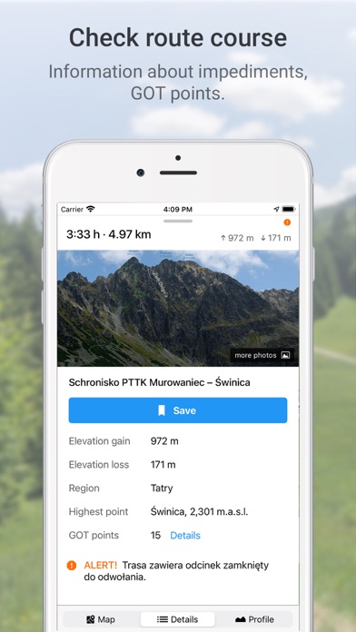
- information about impediments on route,
- GOT points for planned route,
- showing your current location on the map,
- compass,
- track recording, showing elapsing distance and time,
- list of recorded tracks,
- searching for places and showing them on the map,
- displaying information about places your searched for: photos and opinions taken from mapa-turystyczna.pl website,
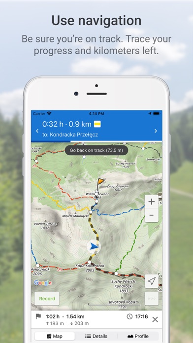
- navigation on planned route,
- detailed touristic maps layer, also available for download.
Available trails from regions:
* Beskidy
** Beskid Makowski
** Beskid Mały
** Beskid Niski
** Beskid Sądecki
** Beskid Śląski
** Beskid Śląsko-Morawski
** Beskid Wyspowy
** Beskid Żywiecki
** Bieszczady
** Gorce
* Sudety (Sudeten)
** Góry Bardzkie
** Góry Bystrzyckie
** Góry Orlickie
** Góry Izerskie
** Góry Kaczawskie
** Góry Kamienne
** Góry Opawskie
** Góry Sowie
** Góry Stołowe (Table Mountains)
** Góry Wałbrzyskie
** Góry Złote
** Góry Bialskie
** Karkonosze
** Kotlina Jeleniogórska
** Masyw Śnieżnika
** Rudawy Janowickie
* Pogórze Sudeckie
** Pogórze Izerskie
** Pogórze Kaczawskie
* Przedgórze Sudeckie
** Masyw Ślęży
** Przedgórze Paczkowskie
** Równina Świdnicka
** Wzgórza Niemczańsko-Strzelińskie
** Wzgórza Strzegomskie
* Pogórze Beskidzkie
** Pogórze Ciężkowickie
** Pogórze Przemyskie
** Pogórze Rożnowskie
** Pogórze Strzyżowskie
** Pogórze Dynowskie
** Pogórze Wielickie
** Pogórze Wiśnickie
* Other
** Wolin Island
** Góry Świętokrzyskie
** Płaskowyż Suchedniowski
** Kampinos Forest
** Jura Krakowsko-Częstochowska
** Brama Krakowska (Cracow's surroundings)
** Pieniny
** Pogórza Przedtatrzańskie
** Działy Orawskie
** Tatry (Tatra Mountains)
* Slovakia
** Góry Choczańskie (Choč Mountains)
** Skoruszyńskie Wierchy
** Góry Kysuckie (Kysuce Highlands)
** Magura Orawska (Orava Magura)
** Magura Spiska (Spiš Magura)
** Mała Fatra (Lesser Fatra)
** Niżne Tatry (Low Tatra Mountains)
** Słowacki Raj (Slovak Paradise)
** Wielka Fatra (Great Fatra)
** Wysokie Tatry (High Tatra Mountains)
Planning routes and displaying information about places need internet connection.
Continued use of GPS running in the background can dramatically decrease battery life.
Terms of Use (EULA): https://mapa-turystyczna.pl/regulamin
The main functionality is planning routes leading along official hiking trails in the mountains and foothills of Poland. The app finds a route quick and easy, displays it on a map, shows its length, estimated time, detailed course and elevation profile. It also shows your current location.
Routes are displayed on detailed Touristic map layer with contours and terrain shading, which contains peaks, passes, parkings and other points of interest. It's also possible to download maps of regions listed further in this description and use them offline.
Tracks recording
Second main functionality is recording tracks. You can then share it with your friends!
Interesting places
The app also displays information about points of interest: photos and opinions taken from the mapa-turystyczna.pl website.
Detailed functionalities:
- planning routes based on given points; points can be chosen from map or found using the search box,
- intelligent search suggestions, considering spots closest to your location and those most popular,
- displaying routes on a map along with their length, estimated time, route details (spots and trails) and elevation profile,
- information about impediments on route,
- GOT points for planned route,
- showing your current location on the map,
- compass,
- track recording, showing elapsing distance and time,
- list of recorded tracks,
- searching for places and showing them on the map,
- displaying information about places your searched for: photos and opinions taken from mapa-turystyczna.pl website,
- navigation on planned route,
- detailed touristic maps layer, also available for download.
Available trails from regions:
* Beskidy
** Beskid Makowski
** Beskid Mały
** Beskid Niski
** Beskid Sądecki
** Beskid Śląski
** Beskid Śląsko-Morawski
** Beskid Wyspowy
** Beskid Żywiecki
** Bieszczady
** Gorce
* Sudety (Sudeten)
** Góry Bardzkie
** Góry Bystrzyckie
** Góry Orlickie
** Góry Izerskie
** Góry Kaczawskie
** Góry Kamienne
** Góry Opawskie
** Góry Sowie
** Góry Stołowe (Table Mountains)
** Góry Wałbrzyskie
** Góry Złote
** Góry Bialskie
** Karkonosze
** Kotlina Jeleniogórska
** Masyw Śnieżnika
** Rudawy Janowickie
* Pogórze Sudeckie
** Pogórze Izerskie
** Pogórze Kaczawskie
* Przedgórze Sudeckie
** Masyw Ślęży
** Przedgórze Paczkowskie
** Równina Świdnicka
** Wzgórza Niemczańsko-Strzelińskie
** Wzgórza Strzegomskie
* Pogórze Beskidzkie
** Pogórze Ciężkowickie
** Pogórze Przemyskie
** Pogórze Rożnowskie
** Pogórze Strzyżowskie
** Pogórze Dynowskie
** Pogórze Wielickie
** Pogórze Wiśnickie
* Other
** Wolin Island
** Góry Świętokrzyskie
** Płaskowyż Suchedniowski
** Kampinos Forest
** Jura Krakowsko-Częstochowska
** Brama Krakowska (Cracow's surroundings)
** Pieniny
** Pogórza Przedtatrzańskie
** Działy Orawskie
** Tatry (Tatra Mountains)
* Slovakia
** Góry Choczańskie (Choč Mountains)
** Skoruszyńskie Wierchy
** Góry Kysuckie (Kysuce Highlands)
** Magura Orawska (Orava Magura)
** Magura Spiska (Spiš Magura)
** Mała Fatra (Lesser Fatra)
** Niżne Tatry (Low Tatra Mountains)
** Słowacki Raj (Slovak Paradise)
** Wielka Fatra (Great Fatra)
** Wysokie Tatry (High Tatra Mountains)
Planning routes and displaying information about places need internet connection.
Continued use of GPS running in the background can dramatically decrease battery life.
Terms of Use (EULA): https://mapa-turystyczna.pl/regulamin
🆕 What's New · v2.0.30
- improvements for recording tracks
Profile & Insights
Everything we know — and don't — about this app and its company.
Identification
- App name
- Hiking Map Poland
- Developer
- Mapa Turystyczna sp. z o.o.
- Bundle ID
- pl.mapaturystyczna.app
- App Store URL
- Open in App Store
- Category
- Travel
- Content rating
- 4+
- Languages
- EN, PL
Company
- Website
- mapa-turystyczna.pl
- Tagline
- Polecane trasy
- Description
- Planowanie tras po szlakach turystycznych. Punkty GOT, zdjęcia, opinie i informacje o miejscach i szlakach. Tatry, Beskidy, Sudety, pogórza i inne.
- Founded
- Not found
- HQ / Address
- Not found
- Employees
- Not found
- Logo
- OG image
Revenue
- Verified revenue / mo
- Not found
- AI revenue estimate / mo
- Not found
- AI annual estimate
- Not found
- ML model estimate / mo
- $201/mo
- Top-grossing rank
- Outside top 100 in US Travel
- All-time revenue
- Not found
- Pricing
- Not found
Founder
- Name
- Not found
- X / Twitter
- Not found
- Not found
- GitHub
- Not found
- X followers
- Not found
- Public statements
- Not found
Funding
- Total raised
- Not found
- Last round
- Not found
- Investors
- Not found
- Crunchbase
- Not found
- AngelList
- Not found
Press & Links
- Articles found
- Not found
- Listed on
- Not found
- Blog
- Not found
- Press / News
- Not found
Contacts & Socials
- Socials
- admin@mapa-turystyczna.pl
- Phone
- Not found
- Contact page
- Not found
- About page
- Not found
📈Ratings growth97 ratings+9600% lifetimeShow 3-year history estimate ▾
Tracked (6 weeks) Pre-tracking estimate (37 weeks) · model-based, ±5% noise · anchored to release date and current value
🌍Geographic ReachNot ranked
This app is currently outside the top 100 grossing in all 9 countries we monitor (US, UK, DE, FR, JP, CA, AU, BR, IN). Niche or new apps often launch this way — popularity rankings appear once daily revenue clears the regional threshold.
Profile is built from iTunes Lookup + developer site scrape + ML revenue model. Empty fields show "Not found" — additional sources (Crunchbase, X, IndieHackers, Acquire.com) coming.


