


 60
60

BU Score
Solid
Great Britain Topo Maps


✍️ BU Analytics Review
“
Great Britain Topo Maps is an Android app from ATLOGIS Geoinformatics GmbH & Co. KG in the Maps & Navigation category, currently rated 4.5★ across 764 ratings. Initial signal reads as mixed reviews — supporters praise core features while critics cite stability/value gaps.
Our BU Score puts it at 60 — Solid (established niche player). For a Maps & Navigation app, that means established niche player.
Track changes month-over-month in the Performance section below — live snapshot history and revenue forecast included.
📊 Performance Tracking LIVE
Loading…
Rating
—
Reviews
—
Forecast Revenue / mo
—
Snapshots tracked
0
since first record
Range:
💰 Forecast Revenue / mo
MODELRevenue forecast computed from BU's 234 trigger model on each snapshot. Calibrated against ground-truth from 58 verified-revenue apps.
🔬Forecast Breakdown — Why This Estimate?Top 3 of 3 triggers
Our ML model uses 200+ signals from public data. These are the most influential for this app:
| Excellent rating (4.5★)METRIC | +$2,200 | |
| Ad-supported / freemiumMETRIC | +$600 | |
| Early-stage install base (764 ratings)METRIC | +$400 |
METRIC = structural app data · REVIEW = mined from user reviews · ✓ VERIFIED = Stripe-verified anchor (TrustMRR)
📈 Reviews Growth
LIVECumulative review count from first BU snapshot. Each point = a tracked update.
⭐ Rating Trend
LIVEAverage rating evolution. Updates with each new review batch.
🗓️ Snapshot Timeline
HISTORYEach bar shows a tracked update and the metric delta from the previous snapshot.
App Specs
🔐 Own this app? Claim & verify MRR →🔖 v7.8.7🔄 updated 2mo ago📂 Maps & Navigation💰 Free
📝 About this app
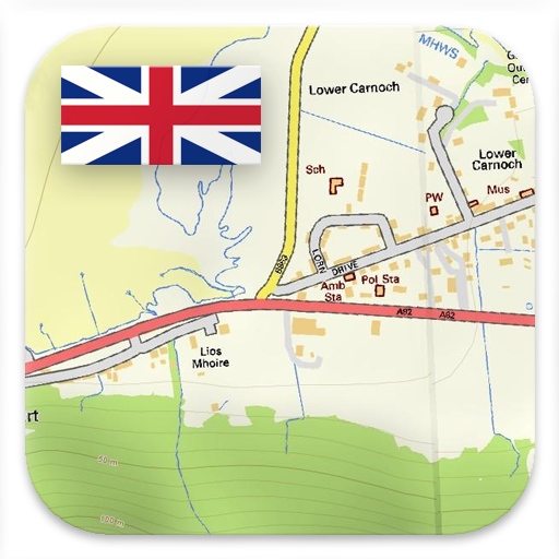
Easy to use Outdoor/Offline GPS navigation app with access to the best ORDNANCE SURVEY topographic maps and satellite images for UK (England, Wales & Scotland).
Turn your Andoid Phone/Tablet into an outdoor GPS for trips into the backcountry WITHOUT CELL COVERAGE. This app gives you similar mapping options as you might know from Garmin or Magellan GPS handhelds.
+++ Includes FREE OS 1:10.000 StreetView® maps ! +++
++ All topo maps are improved with HILLSHADING and contour lines generated from OS Terrain 50 - EXCLUSIVELY in this app ++
Included FREE map layers:
• OS Topo Maps: This layer combines OS VectorMap District™ and 1:10.000 OS StreetView® maps, enriched with hillshading, contour lines and additional placenames !
• OpenStreetMaps : These crowdsourced maps are a very useful addition to the OS maps
• AtloMaps OSM Maps with LiDAR hillshading (worldwide)
• CyclOSM maps for cycling routes
• Google Road Map (online access only)
• Google Satellite Images (online access only)
• Google Terrain Map (online access only)
• Bing Road Map (online access only)
• Bing Satellite Images (online access only)
• ESRI Topographic, Aerial, and Street Maps (online only)
• Earth At Night
Enhance maps with additional overlays:
• Hiking, cycling, MTB, and winter sports routes worldwide
• 10 m contour lines worldwide
• Hillshade overlay worldwide
• OpenSeaMap
Available Premium Maps:
1:25.000 OS EXPLORER MAPS can be downloaded via In-App Purchase. Explorer maps costs vary from 5.5 £ to 28.5 £ per county (One time fee - Explorer maps can be installed on all devices that are logged to purchasers Google account). For example the whole county of Aberdeenshire as 1:25.000 Explorer maps costs only 15.45 £.
And: With the purchase of a 1:25.000 Explorer map cache pack ALL PRO Features WILL BE UNLOCKED !
All OS Explorer maps are in excellent quality with HILLSHADING (only in our app) !
Why should I obtain OS Explorer maps ? Answer: These are the best maps for hiking and other outdoor activities. Explorer maps contain many features (like small trails or points of interest) that are missing in other map sets.
Main features for outdoor-navigation:
• Create and edit Waypoints
• GoTo-Waypoint-Navigation
• Track Recording (with speed, elevation and accuracy profile)
• Tripmaster with fields for odometer, average speed, bearing, elevation, etc.
• GPX/KML/KMZ Export
• Search (placenames, POIs, streets)
• Customizable datafields in Map View and Tripmaster (e.g. Speed, Distance, Compass, ...)
• Share Waypoints, Tracks or Routes (via eMail, Whatsapp, Dropbox, Facebook, ..)
• Display coordinates in Lat/Lon, UTM or MGRS/USNG (Military Grid/ US National Grid)
• Record & share tracks with statistics & elevation profile
• Rotate map (Track Up & North Up)
• Get Elevation by long click on map
• Track Replay
• and many more ...
Available Pro features: (Pro features available via In App Purchase or come free when OS Explorer maps are purchased)
• Offline Use - no cell coverage needed
• Easy+Fast Bulk-download of map tiles for OFFLINE USAGE (not for Google and Bing maps)
• Create and edit Routes
• Route-Navigation (hiking & cycling profiles)
• GPX/KML/KMZ Import
• unlimited Waypoints & Tracks
• Add Tile-Server
• No Ads
Offline Use:
All viewed map tiles are kept in cache. To cache large areas you need to purchase Pro features.
Use this navigation app for outdoor activities like hiking, biking, camping, climbing, riding, skiing, canoeing, hunting, offroad 4WD tours or search&rescue (SAR).
Add custom waypoints in longitude/latitude, UTM or MGRS/USNG format with WGS84 datum.
Import/Export/Share GPS-Waypoints/Tracks/Routes in GPX or Google Earth KML/KMZ format.
Preload FREE map data for areas without cell service (Pro feature !).
This app does NOT provide 1:50.000 OS Landranger maps: There is no need for the Landrangers as the included free OS Topo Map layer is better !
Comments and feature requests to support@atlogis.com
Profile & Insights
Everything we know — and don't — about this app and its company.
Identification
- App name
- Great Britain Topo Maps
- Developer
- ATLOGIS Geoinformatics GmbH & Co. KG
- Bundle ID
- com.atlogis.ukmaps
- App Store URL
- Open in App Store
- Category
- Maps & Navigation
- Content rating
- Not found
- Languages
- Not found
Company
- Website
- Not found
- Tagline
- Not found
- Description
- Not found
- Founded
- Not found
- HQ / Address
- Not found
- Employees
- Not found
- Logo
- Not found
Revenue
- Verified revenue / mo
- Not found
- AI revenue estimate / mo
- Not found
- AI annual estimate
- Not found
- ML model estimate / mo
- $491/mo
- Top-grossing rank
- Not found
- All-time revenue
- Not found
- Pricing
- Not found
Founder
- Name
- Not found
- X / Twitter
- Not found
- Not found
- GitHub
- Not found
- X followers
- Not found
- Public statements
- Not found
Funding
- Total raised
- Not found
- Last round
- Not found
- Investors
- Not found
- Crunchbase
- Not found
- AngelList
- Not found
Press & Links
- Articles found
- Not found
- Listed on
- Not found
- Blog
- Not found
- Press / News
- Not found
Contacts & Socials
- Socials
- Not found
- Not found
- Phone
- Not found
- Contact page
- Not found
- About page
- Not found
Profile is built from iTunes Lookup + developer site scrape + ML revenue model. Empty fields show "Not found" — additional sources (Crunchbase, X, IndieHackers, Acquire.com) coming.
More by ATLOGIS Geoinformatics GmbH & Co. KG
View all →
Russian Topo Maps
★ 4.7 · 67,526 reviews

US Topo Maps
★ 4.6 · 10,905 reviews
Russian Topo Maps Pro
★ 4.3 · 3,961 reviews
Spain Topo Maps
★ 4.7 · 2,426 reviews
US Topo Maps Pro
★ 4.7 · 1,790 reviews
Australia Topo Maps
★ 4.5 · 1,611 reviews
Canada Topo Maps Free
★ 4.4 · 1,489 reviews
New Zealand Topo Maps
★ 4.7 · 1,373 reviews
More Maps & Navigation

Grab - Taxi & Food Delivery
★ 4.8 · 16,301,698 reviews

inDrive. Rides with fair fares
★ 4.8 · 14,419,666 reviews

Yandex Go: Taxi Food Delivery
★ 4.7 · 13,846,529 reviews

Bolt: Request a Ride
★ 4.8 · 9,965,117 reviews

Rapido: Bike-Taxi, Auto & Cabs
★ 4.8 · 4,086,095 reviews

Ola: Book Cab, Auto, Bike Taxi
★ 4.8 · 3,464,588 reviews

Yango: taxi, food, delivery
★ 4.8 · 3,215,778 reviews

99: Rides, Food, Pay
★ 4.3 · 3,010,021 reviews
Browse BU Analytics
📚 All 55,000+ Books
🜍 Alchemy & Hermeticism
🔮 Magic & Ritual
🌙 Witchcraft & Paganism
⭐ Astrology & Cosmology
🃏 Divination & Tarot
📜 Maps & Navigation
✡️ Kabbalah & Jewish Mysticism
🕉️ Mysticism & Contemplation
🕊️ Theosophy & Anthroposophy
🏛️ Freemasonry & Secret Societies
👻 Spiritualism & Afterlife
📖 Sacred Texts & Gnosticism
👁️ Supernatural & Occult Fiction
🧘 Spiritual Development
📚 Esoteric History & Biography
Info
About BU Analytics