What ArcGIS Earth actually does (from store listing)
ArcGIS Earth transforms your mobile device into an interactive 3D globe for exploring geospatial data. Access authoritative organizational data, collect field data, perform measurements and exploratory analysis, and share insights with others. Whether you are online or offline, ArcGIS Earth puts the power of 3D visualization at your fingertips. Collaborate with key stakeholders to accelerate decision-making through a shared 3D perspective or digital twin of your data.
Key Features:
- View ma…
ArcGIS Earth transforms your mobile device into an interactive 3D globe for exploring geospatial data. Access authoritative organizational data, collect field data, perform measurements and exploratory analysis, and share insights with others. Whether you are online or offline, ArcGIS Earth puts the power of 3D visualization at your fingertips. Collaborate with key stakeholders to accelerate decision-making through a shared 3D perspective or digital twin of your data.
Key Features:
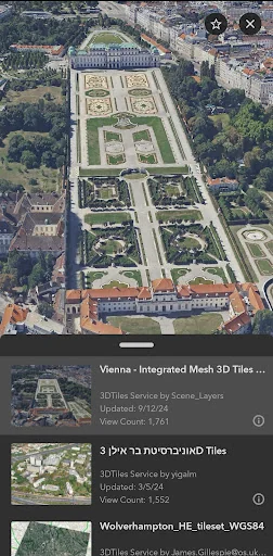
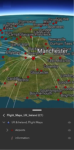
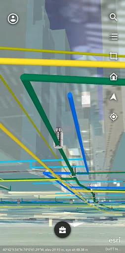
- View maps, GIS layers, and 3D content.
- Explore and visualize open 3D standards.
- Securely connect to your organizations ArcGIS Online or ArcGIS Enterprise portal.
- Search for places using world locator service or custom locator service.
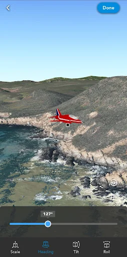
- Draw points, lines, and areas on an interactive 3D globe.
- Add notes and attach photos to drawings.
- Share drawings as KMZs or publish to ArcGIS Portal.
- Create and share tours using placemarks or geotagged photos.
- Conduct interactive 2D and 3D measurements.
- Conduct 3D exploratory analysis like line of sight and viewshed.
- Record GPS tracks and save as a KMZ or publish to ArcGIS Portal.
- Integrate with other device apps to enable 3D visualization in field workflows.
- Position 3D data on a surface to see it in Augmented Reality.
Supported Online Data Services: ArcGIS Map Service, Image Service, Feature Service, Scene Service, Web Maps, Web Scenes, 3D Tiles Hosted Service, and KML / KMZ.
Supported Offline Data: Mobile Scene Package (.mspk), KML and KMZ files (.kml and .kmz), Tile Packages (.tpk and .tpkx), Vector Tile Packages (.vtpk), Scene Layer Packages (.spk and .slpk), GeoPackage (.gpkg), 3D Tiles (.3tz), Raster Data (.img, .dt, .tif, .jp2, .ntf, .sid, .dt0…)
Note: An account is not required to browse public data on ArcGIS Online and ArcGIS Living Atlas of the World, the world's foremost collection of geospatial information.
Note: This app requires you to have a licensed ArcGIS user type to access organizational content and services.
Comparable Android apps
The five apps in Productivity with the closest revenue to ArcGIS Earth. Click any to see its detail page.
Each forecast combines App Store rating, ratings count, monetisation model, pricing tier, IAP signals and ad-supported flag.
The base estimate is then multiplied by a per-category scaling factor learned from apps with founder-verified MRR.
Every number on this page comes from public APIs and bumetric's own snapshot history.
Full methodology covers input variables, accuracy bands per category and how we treat apps without comparable anchors.
See also the live data on ArcGIS Earth's tracker page for current rating, reviews and snapshot timeline.
Building something similar? Get a free AI audit with $-revenue forecasts for every recommendation.

 Udupi Mallige - Jasmine Flower
 BIMx
BIMx
 My TimeBook
 Calendar – Smart Scheduler
 Ti je Musliman