ML revenue forecast.
Calibrated against 2454 apps in this category.
Confidence band
±15%
High — many comparable apps with verified data
At a glance
Earns 4.52× more than the category median (849/mo).
Ranks #293 of 2,454 in Travel (top 11.9% by revenue).
Launched Sep 21, 2016 · last updated Dec 12, 2025.
24 months of snapshot history tracked.
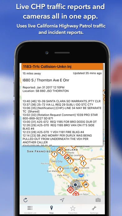
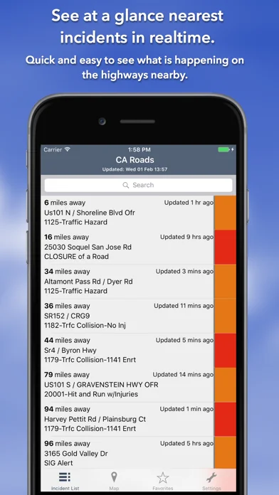
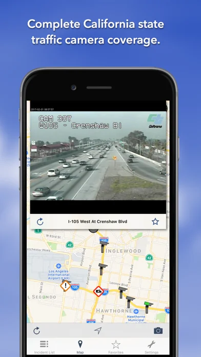
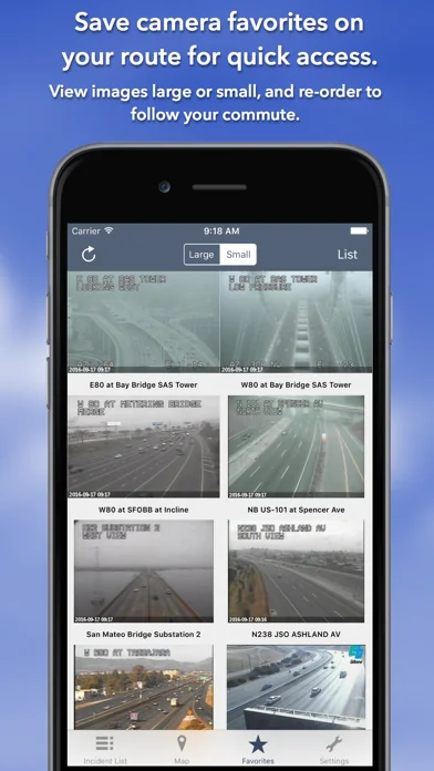
What the app looks like
Live screenshots from the App Store, captured by our snapshot worker. Tap any image to enlarge.
California State Roads's revenue trajectory
Forecast revenue from snapshot history. Last 24 months.
Where California State Roads sits in Travel
Revenue distribution of 2454 comparable apps. California State Roads highlighted.
California State Roads vs comparable apps
Revenue trajectory side-by-side. Bold = California State Roads, ghosted = peers.
App spec
Version
4.0
Last update
Dec 12, 2025
Launched
Sep 21, 2016
Min OS
13.0
Rating
4+
Price
Free
Monetization
Paid
Languages
EN
What California State Roads actually does (from App Store listing)
Live CHP traffic reports and cameras for California. View up-to-the-minute California Highway Patrol logs. One time purchase, no subscription required. The app was updated during December 2025.
KEY FEATURES:
Live data from California Highway Patrol (CHP):
- 1,568 traffic cameras covering California State.
- Today screen widget to show at a glance the nearest current traffic incidents
- Dark Mode throughout the app.
- Sharing: you can easily share traffic camera images with your Twitter follower…
Live CHP traffic reports and cameras for California. View up-to-the-minute California Highway Patrol logs. One time purchase, no subscription required. The app was updated during December 2025.
KEY FEATURES: Live data from California Highway Patrol (CHP): - 1,568 traffic cameras covering California State. - Today screen widget to show at a glance the nearest current traffic incidents - Dark Mode throughout the app. - Sharing: you can easily share traffic camera images with your Twitter followers, Facebook friends or via email etc. - Optimised for all iPhone and iPad models.
MAP VIEW - Shows current incidents and traffic cams. - Each incident is color coded as well as being represented by an icon showing the incident type. - Clicking on an incident displays more detail right there on the map. - The map view can also show live traffic camera images.
LIST VIEW - Shows current incidents in order of distance from your current location (closest incidents are shown first). - Each incident is color-coded to indicate the severity of the delay. - You can quickly see the distance the incident is from you, the road name, the type of incident and when the incident log was updated. - The detail view shows the description and log of the incident together with a map showing the location. - Full search functionality, works across both the list and map views.
TRAFFIC CAMS - Toggle show/hide the cameras on the map. - Touch a camera icon on the map to view a live camera image.
TRAFFIC CAM FAVORITES - Save your favorite cameras for quick access to see how clear/congested your usual routes are.
TODAY WIDGET - Shows at a glance the nearest current traffic incidents without launching the app.
PERSONALISE - Toggle traffic information on the map. - Toggle auto refresh of camera images (will refresh every 10 seconds). - Toggle always show map on app launch. - Toggle roadworks on/off. - You can configure which incidents are displayed according to the severity of the delay caused. - Miles or KM setting.
CHP GLOSSARY - Quick access to a full CHP glossary of terms to help you interpret traffic reports.
CONTACT - Email me for feature requests/bug reports etc. I would love to hear from you!
🆕 What's new · v4.0
- Updated User Interface for iOS26
- Fixed scrolling bug on the incident detail screen.
- Now remembers if you have selected large or small traffic camera images on the "Favourites" tab.
Comparable iOS apps
The five apps in Travel with the closest revenue to California State Roads. Click any to see its detail page.
Each forecast combines App Store rating, ratings count, monetisation model, pricing tier, IAP signals and ad-supported flag.
The base estimate is then multiplied by a per-category scaling factor learned from apps with founder-verified MRR.
Every number on this page comes from public APIs and bumetric's own snapshot history.
Full methodology covers input variables, accuracy bands per category and how we treat apps without comparable anchors.
See also the live data on California State Roads's tracker page for current rating, reviews and snapshot timeline.
Building something similar? Get a free AI audit with $-revenue forecasts for every recommendation.

 Barcelona Travel Guide -
 Packing (+TO DO!)
 Visorando Walking Routes
 States Visited USA
 Flying Calmly