What Cogo Survey Pro actually does (from store listing)
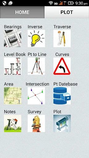
Cogo Survey Pro is a surveying application that includes:
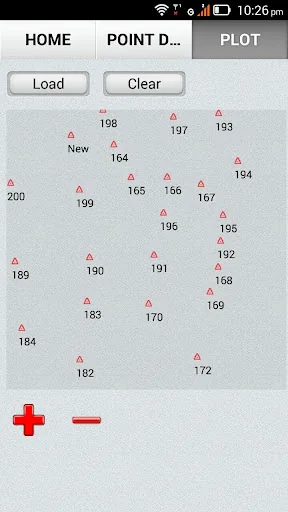
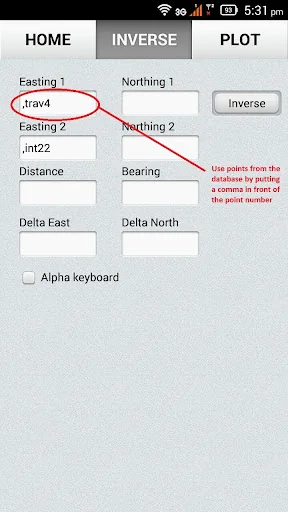
Points Database---> Import a .csv points file or add manually. Points form the database can be used in all the other modules by calling the point number with a comma in front of the point number.(ie ",pt105" in the easting field). Export to .csv and save to internal storage or sand via email.
Plot Screen--> Display the points graphically from the point database.
Area By Coordinates---> Calculate the area of a shape with up to …
Cogo Survey Pro is a surveying application that includes:
Points Database---> Import a .csv points file or add manually. Points form the database can be used in all the other modules by calling the point number with a comma in front of the point number.(ie ",pt105" in the easting field). Export to .csv and save to internal storage or sand via email.
Plot Screen--> Display the points graphically from the point database.
Area By Coordinates---> Calculate the area of a shape with up to 20 sides. Points are stored in a table that is editable.
2 & 3 Point Arcs---> Create arcs from 2 points and a radius or with 3 points. Then divide the curve in equal parts.
Bearing Conversions----> Convert bearings from decimal to DMS and DMS to decimal.
Bearing Calculator---> Add or subtract bearings in DegMinSec format
Survey---> Convert field data into XYZ coordinates. Input Hz bearing , vertical bearing and slope distance to convert to coordinates.
Inverse---> Compute bearing and distance between coordinates.
Inverse List---> Get a list of bearings and distances form a nominated point to all points in the database.
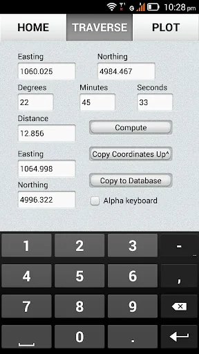
Traverse---> Calculate co-ordinates from bearing and distance of an occupied station.
Pt To Line---> Calculate the offset and chainage of a point from a line. Or Calculate coordinates by inputting chainage and offset.
Level Book---> A leveling sheet that allows the surveyor to input readings from a level run and compute elevations on the go.Export the data to a .csv file and send via Email. Never again get to the end of a loop without knowing if there has been a mistake made
Intersection By Points---> Calculate the coordinates of a point by intersecting lines with known coordinates. Can project a line through when lines don't intersect.
Curve Calc---> Calculate the middle ordinate by knowing radius and chord length.
Settings---> Choose a custon delimiter. Change between a light and dark theme. Change form degrees to gradians.
COMPATIBILITY
This app will not work on every single device and version of Android. There are hundreds of android devices and a wide variety of chip sets and testing them all is not possible.
FEEDBACK
Please leave feed back about any bugs or requested improvements.
DISCLAIMER
This is open-source application provided free of charge without advertising. It is provided with no warranty whatsoever. By using it the user agrees that the author is not responsible for any financial loss as a result of using this application. While the application has automatic backup features the author is not responsible for any loss of data that may occur.
Comparable Android apps
The five apps in Tools with the closest revenue to Cogo Survey Pro. Click any to see its detail page.
Each forecast combines App Store rating, ratings count, monetisation model, pricing tier, IAP signals and ad-supported flag.
The base estimate is then multiplied by a per-category scaling factor learned from apps with founder-verified MRR.
Every number on this page comes from public APIs and bumetric's own snapshot history.
Full methodology covers input variables, accuracy bands per category and how we treat apps without comparable anchors.
See also the live data on Cogo Survey Pro's tracker page for current rating, reviews and snapshot timeline.
Building something similar? Get a free AI audit with $-revenue forecasts for every recommendation.
 Wireless Charging Checker
 Device Info: System & CPU Info
 aGrep
aGrep
 Pashto Keyboard Pro
 Голос "Ника" для DVBeep