What GPS Photo Viewer actually does (from store listing)
<b>Please watch the teach video to know how to use it. (Have description if watch video from PC or Notebook.)</b>
When you go to travel and take a picture, I suggest you to enable camera's GPS.
After you enable camera's GPS function, then the GPS latitude and longitude will record in the captured photo.
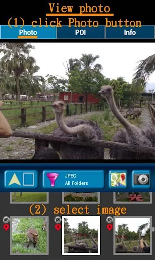
This application is help you to check the photo have a GPS info or not. And help to launch the Google map.
If your photo (jpeg file) doesn't have a GPS info, this application also can …
Please watch the teach video to know how to use it. (Have description if watch video from PC or Notebook.)
When you go to travel and take a picture, I suggest you to enable camera's GPS.
After you enable camera's GPS function, then the GPS latitude and longitude will record in the captured photo.
This application is help you to check the photo have a GPS info or not. And help to launch the Google map.
If your photo (jpeg file) doesn't have a GPS info, this application also can help you to edit it. So you can know where to take this picture.
A few years later, you also know where this place is.
Memories are important thing in our life.
So remember enable GPS when take a picture!!!
Function :
1. Fast check/edit photo's GPS information.
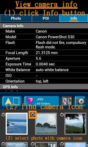
2. Fast check photo's camera information.
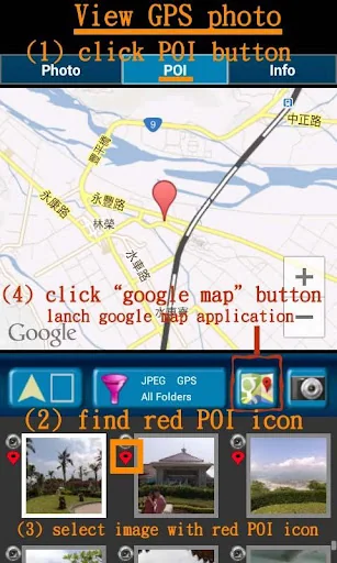
3. Navigate GPS-POI in google map.
4. Launch to "google map application" with photo's GPS location.
5. When launch this application, the final selected photo will be shown. So it is quickly to index the final selected photo. It is convenient!
Purpose :
1. You can copy your GPS photos to your friends, and then they can go there if they are interest.
2. Want to know where to take the picture. (Take a GPS photo when park your car, you will find your car easily.)
3. Want to know the "focal length", "aperture", "ISO" value in the photo.
V1.1.0:
1. change MAP to google map V3. a) support traffic/weather/panoramio layer.
b) support street view.
c) support place search.
V1.1.1:
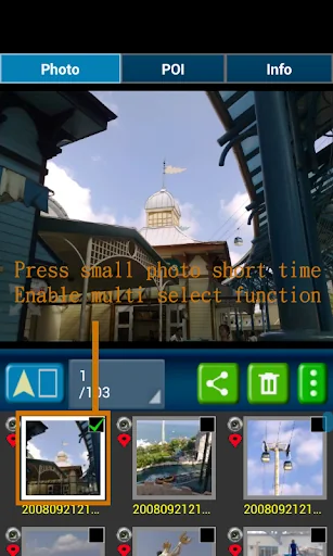
1. Support edit photo's latitude/longitude. (Only JPEG file can edit latitude/longitude) (a-1) Press the small photo a long time to enable photo multi-select.
(a-2) Select photos. (up to 20 photos)
(a-3) Select option button, then tap "edit poi" button to enter edit-page.
Others :
1. It could be slow at first time loading image. After decoding finish, it will be fast.
2. Remember turn on GPS funtion when you take a picture. And the photo will contail GPS info.
3. Your phone need already install "google map application" and "google play service" before run this application.
4. Tap the small picture for some time, share/delete/rename/rotate function will enable.
PS: In the Line/Facebook photo sharing, latitude and longitude info will be removed. If you want to share the latitude and longitude info, we recommend to use email/Gmail.
[Q&A] :
1. How to capture a photo that contain a GPS tag?
Ans:
1) Enable `Use wireless networks` and `Use GPS satellites` in `Location services` page.
2) Enable WIFI or 3G/4G network for fast locaton search.
3) Enable GPS function in the camera application.
【PS】
Please like us on Facebook. Give us the power of love.
https://www.facebook.com/jkfantasy
Comparable Android apps
The five apps in Travel & Local with the closest revenue to GPS Photo Viewer. Click any to see its detail page.
Each forecast combines App Store rating, ratings count, monetisation model, pricing tier, IAP signals and ad-supported flag.
The base estimate is then multiplied by a per-category scaling factor learned from apps with founder-verified MRR.
Every number on this page comes from public APIs and bumetric's own snapshot history.
Full methodology covers input variables, accuracy bands per category and how we treat apps without comparable anchors.
See also the live data on GPS Photo Viewer's tracker page for current rating, reviews and snapshot timeline.
Building something similar? Get a free AI audit with $-revenue forecasts for every recommendation.
 Street View 360 - Earth Map
 MIGO Ebike
 Aanavandi
 Avis Car Hire
 렌트카 카모아 - 국내도 해외도 렌트카는 카모아