What Hiking Map Poland actually does (from store listing)
Hiking Map Poland helps you plan hiking routes and navigate the trail.
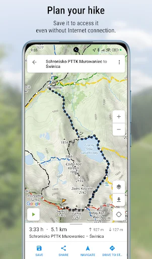
<b>Route planning</b>
The main functionality is planning routes leading along official hiking trails in the mountains and foothills of Poland. The app finds a route quick and easy, displays it on a map, shows its length, estimated time, detailed course and elevation profile. It also shows your current location.
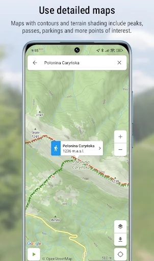
Detailed Touristic map layer with contours and terrain shading contains peaks, passes, parkings and other po…
Hiking Map Poland helps you plan hiking routes and navigate the trail.
Route planning The main functionality is planning routes leading along official hiking trails in the mountains and foothills of Poland. The app finds a route quick and easy, displays it on a map, shows its length, estimated time, detailed course and elevation profile. It also shows your current location.
Detailed Touristic map layer with contours and terrain shading contains peaks, passes, parkings and other points of interest. In Premium version user can download maps of regions listed further in this description and use them offline.
Tracks recording Second main functionality is recording tracks. You can then share it with your friends!
Interesting places The app also displays information about points of interest: photos and opinions taken from the mapa-turystyczna.pl website.
Detailed functionalities: - planning routes based on given points; points can be chosen from map or found using the search box,
- intelligent search suggestions, considering spots closest to your location and those most popular,
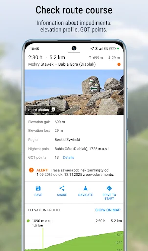
- displaying routes on a map along with their length, estimated time, route details (spots and trails) and elevation profile,
- information about impediments on route,
- GOT points for planned route,
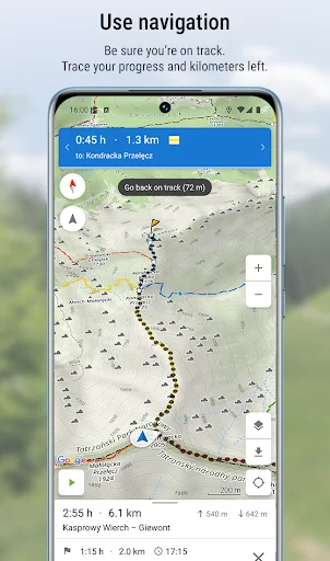
- showing your current location on the map,
- compass,
- track recording, showing elapsing distance and time,
- list of recorded tracks,
- searching for places and showing them on the map,
- displaying information about places your searched for: photos and opinions taken from mapa-turystyczna.pl website,
- navigation on planned route,
- detailed touristic maps layer, also available for download.
Available trails from i.e. regions: * Beskidy
** Beskid Makowski
** Beskid Mały
** Beskid Niski
** Beskid Sądecki
** Beskid Śląski
** Beskid Śląsko-Morawski
** Beskid Wyspowy
** Beskid Żywiecki
** Bieszczady
** Gorce
* Sudety (Sudeten)
** Góry Bardzkie
** Góry Bystrzyckie
** Góry Orlickie
** Góry Izerskie
** Góry Kaczawskie
** Góry Kamienne
** Góry Opawskie
** Góry Sowie
** Góry Stołowe (Table Mountains)
** Góry Wałbrzyskie
** Góry Złote
** Góry Bialskie
** Karkonosze
** Kotlina Jeleniogórska
** Masyw Śnieżnika
** Rudawy Janowickie
* Slovakia
** Góry Choczańskie (Choč Mountains)
** Skoruszyńskie Wierchy
** Góry Kysuckie (Kysuce Highlands)
** Magura Orawska (Orava Magura)
** Magura Spiska (Spiš Magura)
** Mała Fatra (Lesser Fatra)
** Niżne Tatry (Low Tatra Mountains)
** Słowacki Raj (Slovak Paradise)
** Wielka Fatra (Great Fatra)
** Wysokie Tatry (High Tatra Mountains)
App is free. Planning routes and displaying information about places need internet connection. Downloading offline maps and navigation are available in Premium (paid).
Comparable Android apps
The five apps in Travel & Local with the closest revenue to Hiking Map Poland. Click any to see its detail page.
Each forecast combines App Store rating, ratings count, monetisation model, pricing tier, IAP signals and ad-supported flag.
The base estimate is then multiplied by a per-category scaling factor learned from apps with founder-verified MRR.
Every number on this page comes from public APIs and bumetric's own snapshot history.
Full methodology covers input variables, accuracy bands per category and how we treat apps without comparable anchors.
See also the live data on Hiking Map Poland's tracker page for current rating, reviews and snapshot timeline.
Building something similar? Get a free AI audit with $-revenue forecasts for every recommendation.

 Halan: Lending, BNPL, Payments
 Turkish Airlines Flight Ticket
 RailTime
 Distance
 HappyCow - Vegan Food Near You