What Land Calculator: Map Measure actually does (from store listing)
Land Calculator is a powerful, yet easy-to-use app for making area and perimeter measurements for any location.
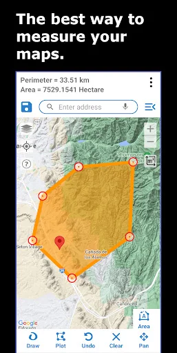
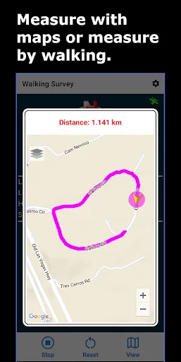
Measure the perimeter and area of any area on a map or use your device's GPS to get the area, perimeter and path length for a place that your walk or drive.
The app's most commonly performed tasks include:
📏 Create a field survey by drawing any shape on a map to get its enclosed area and perimeter. Combine points and curves to make the best possible map survey. Supp…
Land Calculator is a powerful, yet easy-to-use app for making area and perimeter measurements for any location.
Measure the perimeter and area of any area on a map or use your device's GPS to get the area, perimeter and path length for a place that your walk or drive.
The app's most commonly performed tasks include:
📏 Create a field survey by drawing any shape on a map to get its enclosed area and perimeter. Combine points and curves to make the best possible map survey. Supports any shape you can draw!
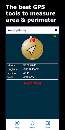
📏 Get land area and perimeter for any shape field by walking or driving its perimeter.
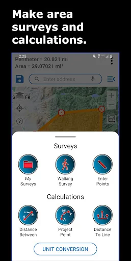
📏 Measure point to point distances with various map tools and survey tools.
📏 Area and perimeter unit conversion tool.
📏 Shortest distance to a line with accurate connecting geodesics.
The app includes:
● Selection of coordinate systems including: WGS 84, British Ordnance Survey (OSG36 Datum), ANS, NAD 27, ED 50, NAD 83 and several others.
● A backup and restore feature: Secure and restore your work using the app's kml backup and importing features. Share surveys to colleagues who may view your work in Google Earth on their desktop computer or phone or in Land Calculator. Got a new phone and all your work is on the old phone? No problem! Import all your old work into your new phone with the application's single click restore process.
● Use the data generated by this application in ArcGIS by converting the app's KML files with ArcGIS' KML2Layer feature, or, use KML Tools to convert the application's KML files to DXF (Drawing Exchange Format) for use in drawing programs like AutoCad and SketchUp.
A GPS-controlled compass and GPS reporting are included to assist with your field surveys.
Who uses this app?
● Used by farmers to calculate equipment needs, seed requirements, estimate water usage, estimate harvest quantity and crop value.
● Used by Real Estate agents to measure property size.
● Insurance agents use the app to measure property size for adjustment purposes.
● Property inspectors use the app to get property measurements used in mortgage calculations.
● Used by land improvement businesses to estimate fencing supply needs and other construction supplies.
If you need to make a highly specialized type of calculation and you don't see the tools in the app for it, contact us at:
support@discipleskies.com
and we will consider developing and adding the specialized tool you need.
Comparable Android apps
The five apps in Tools with the closest revenue to Land Calculator: Map Measure. Click any to see its detail page.
Each forecast combines App Store rating, ratings count, monetisation model, pricing tier, IAP signals and ad-supported flag.
The base estimate is then multiplied by a per-category scaling factor learned from apps with founder-verified MRR.
Every number on this page comes from public APIs and bumetric's own snapshot history.
Full methodology covers input variables, accuracy bands per category and how we treat apps without comparable anchors.
See also the live data on Land Calculator: Map Measure's tracker page for current rating, reviews and snapshot timeline.
Building something similar? Get a free AI audit with $-revenue forecasts for every recommendation.
 Mi Coca-Cola
 Easy Assembly
 Simple Torch - Flashlight
 Unit Converter
 Cute timer app :Parrot Timer