What Map of NYC Subway actually does (from store listing)
Line maps for New York City. It includes a complete set of maps for NYC public transport: subway, bus, railroad, ferry and airport.
No internet connection required.
You can zoom in, zoom out, scroll around. Very simple and easy to use!
This app is excellent for visitors to NYC and permanent New Yorkers alike.
All maps included in the app:
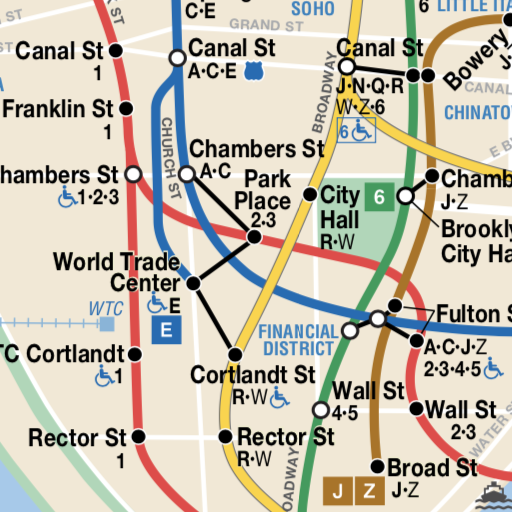
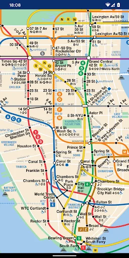
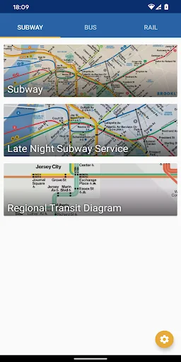
- Subway System
- Subway Late Night Service Map
- Regional Transit Diagram
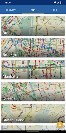
- Bus map for Bronx
- Bus map for Brooklyn
- Bus map for Manhattan…
Line maps for New York City. It includes a complete set of maps for NYC public transport: subway, bus, railroad, ferry and airport.
No internet connection required.
You can zoom in, zoom out, scroll around. Very simple and easy to use!
This app is excellent for visitors to NYC and permanent New Yorkers alike.
All maps included in the app:
- Subway System
- Subway Late Night Service Map
- Regional Transit Diagram
- Bus map for Bronx
- Bus map for Brooklyn
- Bus map for Manhattan
- Bus map for Queens
- Bus map for Staten Island
- Bus map for Staten Island Express Bus
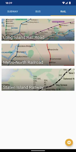
- Rail map for Long Island Rail Road network map (LIRR)
- Rail map for Metro-North Railroad
- Rail map for Staten Island Railway (SIR)
- CT rail
- Hartford line
- New Haven line
- Short Line East
- Amtrak
- CT fastrak
- PATH rail system
- JFK AirTrain
- JFK Airport
- NYC Ferry
- New Jersey Transit
- NJ Transit Train System map
- Huston-Bergen Light Rail
- Newark Light Rail
- River LINE
- Montclair-Boonton Line
- Morristown Line
- Main Line
- Bergen Line
- Pascack Valley Line
- Meadowlands Rail Line
- Gladstone Branch
- Raritan Valley Line
- Northeast Corridor
- North Jersey Coast Line
- Atlantic City Line
- Patco High Speed Line
- City map
- Metro, Subway, and Underground maps
Support indie developers! If you have any problems or feedback, please send an email. Thank you!
Comparable Android apps
The five apps in Maps & Navigation with the closest revenue to Map of NYC Subway. Click any to see its detail page.
Each forecast combines App Store rating, ratings count, monetisation model, pricing tier, IAP signals and ad-supported flag.
The base estimate is then multiplied by a per-category scaling factor learned from apps with founder-verified MRR.
Every number on this page comes from public APIs and bumetric's own snapshot history.
Full methodology covers input variables, accuracy bands per category and how we treat apps without comparable anchors.
See also the live data on Map of NYC Subway's tracker page for current rating, reviews and snapshot timeline.
Building something similar? Get a free AI audit with $-revenue forecasts for every recommendation.
 iNavX: Marine Navigation
 대중교통 - 수도권 버스 지하철
 Такси Дешево
 Bison Futé
 I checked deliveries