What MapOut actually does (from App Store listing)
“MapOut saves the day with its intuitive interface for drawing routes and viewing elevation profiles. I’m genuinely impressed by its powerful features!” – Alee, cyclingabout.com
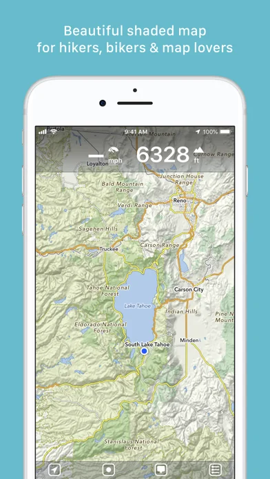
Offline maps covering the entire globe, optimized for iPhone and iPad. As beautiful as a traditional paper map—but far more versatile.
Perfectly tailored for:
- Hikers: Clear, detailed terrain maps accessible even in the most remote locations, without an internet connection.
- Cyclists: Extensive cycling route network…
“MapOut saves the day with its intuitive interface for drawing routes and viewing elevation profiles. I’m genuinely impressed by its powerful features!” – Alee, cyclingabout.com
Offline maps covering the entire globe, optimized for iPhone and iPad. As beautiful as a traditional paper map—but far more versatile.
Perfectly tailored for:
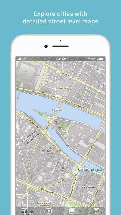
- Hikers: Clear, detailed terrain maps accessible even in the most remote locations, without an internet connection. - Cyclists: Extensive cycling route network with real-time speed and distance tracking. - City Travelers: Detailed city maps complete with essential tourist information. - Map Enthusiasts: Simply elegant maps that are a pleasure to view.
Innovative 3D Tilt View - Tilt your device in any direction to vividly explore terrain details. Learn more at [mapout.app](https://mapout.app).
Powerful Offline Search - Easily find places, streets, mountains, and more—no internet needed.
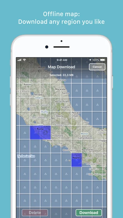
High-Quality Map Data - Built upon the OpenStreetMap project, the "Wikipedia of Maps". Contribute your own corrections and additions at OpenStreetMap.org. - Regularly updated offline maps available for your selected regions.
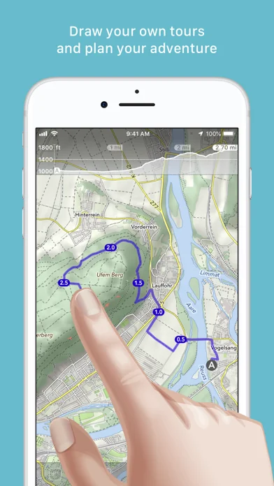
Effortless Tour Planning - Draw: Easily create custom routes and waypoints directly on your map. Adjust existing tours or imported GPX files effortlessly. - Import: Transfer routes to your device via email using a free "MapOut.me" account. Discover countless GPX and KML route files online, ideal for hiking or biking (e.g., gpsies.com). - Record: Capture your adventures and easily share them with friends. - Insights: Quickly see vital information for every tour—distance, elevation changes, route profile, and map details.
Superior Map Viewing Experience - Rapid, hardware-accelerated rendering for smooth navigation. - Continuous zoom with impeccable clarity at every level. - Detailed topographical views featuring contour lines and shading. - Versatile overlays include biking, hiking, skiing routes, sightseeing locations, and public transport networks.
Find comprehensive support and answers in our user manual: https://mapout.app/manual
Each forecast combines App Store rating, ratings count, monetisation model, pricing tier, IAP signals and ad-supported flag.
The base estimate is then multiplied by a per-category scaling factor learned from apps with founder-verified MRR.
Every number on this page comes from public APIs and bumetric's own snapshot history.
Full methodology covers input variables, accuracy bands per category and how we treat apps without comparable anchors.
See also the live data on MapOut's tracker page for current rating, reviews and snapshot timeline.
Building something similar? Get a free AI audit with $-revenue forecasts for every recommendation.

 HP 15c Wissenschaft. Rechner
 StopTheMadness Pro
 AllTrails: Hike, Bike & Run
 RingGo: Mobile Car Parking App
 Jet2 - Holidays and Flights