What Marine Weather Pro| SailGrib actually does (from store listing)
YACHTING WORLD - "IMPRESSIVE" - July 2014
Designed for Iridium GO! and Approved by Iridium.
SaiGrib is a weather and tides forecast app designed for the sailing community, cruisers and raceers, worlwide.
Get all the major models of weather forecast from many different sources in one easy to use app.
Weather data are downloaded as grib files while tides are calculated locally on your device.
Features
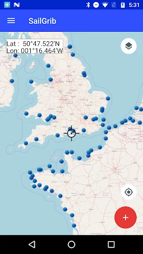
- pan and zoom the map to choose your region
- download data using the best Grib fil…
YACHTING WORLD - "IMPRESSIVE" - July 2014
Designed for Iridium GO! and Approved by Iridium.
SaiGrib is a weather and tides forecast app designed for the sailing community, cruisers and raceers, worlwide.
Get all the major models of weather forecast from many different sources in one easy to use app.
Weather data are downloaded as grib files while tides are calculated locally on your device.
Features
- pan and zoom the map to choose your region
- download data using the best Grib files providers : SailGrib, Great Circle, GMN, OpenWRF, SailDocs...
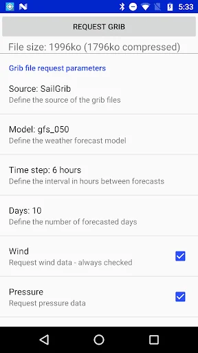
- specify the parameters(wind, pressure...) to your needs
- request can be adjusted to match a maximum file size
- can be used at sea with a satellite phone or the Iridium Go
- offlline maps capability combined with satellite mail allows usage at sea.
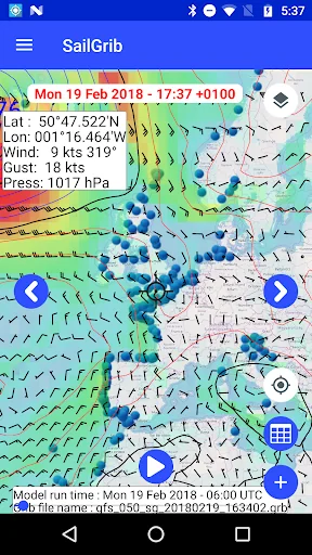
With SailGrib, you can download and view the following data:
- Wind (10m above sea level)
- Pressure (reduced to mean sea level)
- Precipitation (accumulated over 6 hours)
- Total cloud cover
- Air Temperature ( 2m above ground)
- Wave (significant wave height, mean wave direction and period)
- CAPE
- Tidal or oceanic currents
With SailGrib, you can specify the following parameters for your grib file request:
- grib provider : SailGrib, Great Circle, SailDocs, Open WRF, MeteoConsult, GMN, Mercator Ocean for oceanic and coastal currents ....
- request method : direct download (SailGrib, Great Circle, MeteoConsult, GMN) or email (SailDocs, GMN or Great Circle)
- grid resolution: from very high resolution to 2.5°
- time step between forecasts :from 1 hour to 12 hours depending on models
- number of days for the forecast: from 1 to 14 depending on model
- maximum file size. SailGrib estimates the size of the grib file you request and adjust the grid resolution and the time step to make sure your file will size be lower than your set limit.
With SailGrib, you can view the following data:
- Windbarbs
- Isobars
- Precipitation maps
- Cloud cover maps
- Temperature maps
- Waves maps and arrows
- CAPE map
- Currents
WARNINGS:
- Tide forecast are not official and are for reference purpose only.
- Grib files are computer-generated forecast files which are sent without review, and are offered on an as-is basis. There is no assurance that the data is accurate or correct. By using these data you agree to these limitations and assume all the responsibility for their use.
DISCLOSURE:
SailGrib uses the JGRIB Java GRIB decoder (jgrib.sourceforge.net) and OpenStreetMap (www.openstreetmap.org)
Comparable Android apps
The five apps in Weather with the closest revenue to Marine Weather Pro| SailGrib. Click any to see its detail page.
Each forecast combines App Store rating, ratings count, monetisation model, pricing tier, IAP signals and ad-supported flag.
The base estimate is then multiplied by a per-category scaling factor learned from apps with founder-verified MRR.
Every number on this page comes from public APIs and bumetric's own snapshot history.
Full methodology covers input variables, accuracy bands per category and how we treat apps without comparable anchors.
See also the live data on Marine Weather Pro| SailGrib's tracker page for current rating, reviews and snapshot timeline.
Building something similar? Get a free AI audit with $-revenue forecasts for every recommendation.

 My Tide Times Pro
 The Weather Channel - Radar
 Tides Near Me - Plus
 Weather Radar - Meteored News
 My Aurora Forecast Pro