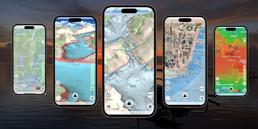
What mKart Marine Navigation actually does (from store listing)
mKart is easy to install and use online marine navigation software (from creators of ECS/ECDIS dKart Navigator) with the fastest chart engine using hybrid ON/OFF sea maps concept and 3D nautical charts.
Product Highlights:
WEB CONSOLE:
E-shop;
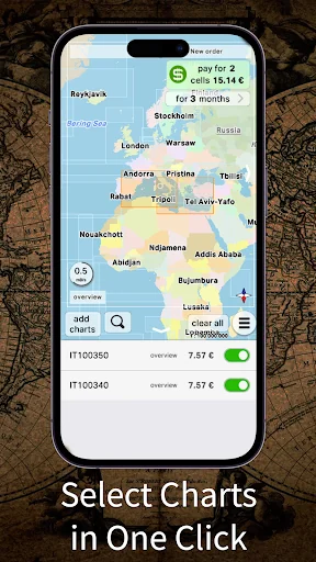
ENCs and cartographic products Catalogue;
Portfolio optimization;
Fleet management;
Roots and tracks;
Data exchange;
Accounting;
SAFETY IS IN FOCUS:
Automatic routing and NO-GO Area display;
Dangerous depths and objects automatic contro…
mKart is easy to install and use online marine navigation software (from creators of ECS/ECDIS dKart Navigator) with the fastest chart engine using hybrid ON/OFF sea maps concept and 3D nautical charts.
Product Highlights:
WEB CONSOLE:
E-shop;
ENCs and cartographic products Catalogue;
Portfolio optimization;
Fleet management;
Roots and tracks;
Data exchange;
Accounting;
SAFETY IS IN FOCUS:
Automatic routing and NO-GO Area display;
Dangerous depths and objects automatic control.
Safe sailing alternative and recommendations;
Meeting points and hazardous traverses calculations.
Background monitoring: dangers’ and ships’ alerts, all along the route.
Apple watch support.
DOCKING:
Click on the chart, select the location and follow the docking path.
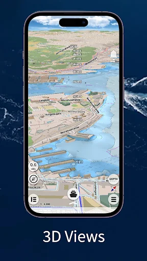
3D MARINE AND OSM CHARTS:
3D marine and OSM charts are uploaded and displayed automatically. 3D sea floor, land’s relief, 3D buildings, ships and infrastructure models contribute to better seafarers orientation and awareness.
FREE NOAA ENCs:
Online NOAA nautical charts are being installed automatically via Internet by customer’s position or while browsing and stored for off-line use. Updating is performed in the same way.
SMART PANELS:
Swipe from below and from side to side. Profiles of seabed relief, safety path simulator, docking.
MARINE ROUTE PLANNER:
Save time with integrated sea and river auto routes functionality. Safety checks is implemented along with route monitoring functionality and warning system.
NO GO ZONE:
Display safety area is filled up graphically on the sea map by only safe depth. Safety zone is calculated trough 3D sea bottom model.
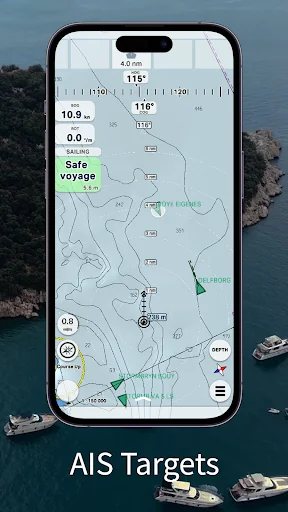
MARINE TRAFFIC:
Marine traffic data can be obtained from open AIS streams over Internet to display and identify dangerous targets.
COMPASS MODE:
Get a quick look around while boat navigation with advanced VR option for better orientation and using visual aids for navigation effectively.
SEARCH:
Search all objects and information on ENC S-57 charts trough SW and data via universal search function.
MARINE WEATHER:
mKart online services allows to deliver highly detailed weather information and forecast.
TRACKS AND WAYPOINTS:
PLT and WPT import and export, recording and displaying on the chart.
Comparable Android apps
The five apps in Maps & Navigation with the closest revenue to mKart Marine Navigation. Click any to see its detail page.
Each forecast combines App Store rating, ratings count, monetisation model, pricing tier, IAP signals and ad-supported flag.
The base estimate is then multiplied by a per-category scaling factor learned from apps with founder-verified MRR.
Every number on this page comes from public APIs and bumetric's own snapshot history.
Full methodology covers input variables, accuracy bands per category and how we treat apps without comparable anchors.
See also the live data on mKart Marine Navigation's tracker page for current rating, reviews and snapshot timeline.
Building something similar? Get a free AI audit with $-revenue forecasts for every recommendation.

 Quick taxi Niksic
 Toilets4London
 One For All Assistant
 Easy Speedometer Basic
 AlgoTrack