Android app
from Ministarstvo pomorstva, prometa i infrastrukture
· Travel & Local
ML forecast★ 3.0 · 443Free
~329/mo
ML revenue forecast.
Calibrated against 30046 apps in this category.
Confidence band
±15%
High — many comparable apps with verified data
At a glance
Earns 2.12× more than the category median (155/mo).
Ranks #4,309 of 30,046 in Travel & Local (top 14.3% by revenue).
Launched Jul 20, 2016 · last updated Mar 30, 2026.
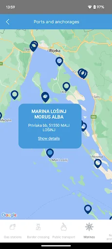
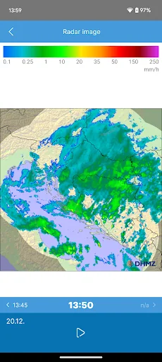
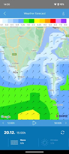
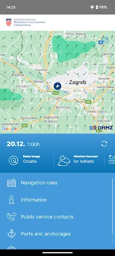
What the app looks like
Live screenshots from the Play Store, captured by our snapshot worker. Tap any image to enlarge.
Nautical Info Service Croatia's revenue trajectory
Forecast revenue from snapshot history. Last 1 months.
Where Nautical Info Service Croatia sits in Travel & Local
Revenue distribution of 30046 comparable apps. Nautical Info Service Croatia highlighted.
Nautical Info Service Croatia vs comparable apps
Revenue trajectory side-by-side. Bold = Nautical Info Service Croatia, ghosted = peers.
App spec
Version
1.3.3
Last update
Mar 30, 2026
Launched
Jul 20, 2016
Price
Free
Monetization
Free
What Nautical Info Service Croatia actually does (from store listing)
Nautical Information Service (nIS) is a free bilingual application for smartphones, intended for owners of yachts and boats, fishermen, divers, swimmers and other people who spend time on the coast and at sea. nIS was developed so that users could provide substantial and detailed information to the local harbormaster's offices and other services for navigation safety, prevention of marine pollution, and especially to search and rescue services, in a quick and simple way. nIS can also provide use…
Nautical Information Service (nIS) is a free bilingual application for smartphones, intended for owners of yachts and boats, fishermen, divers, swimmers and other people who spend time on the coast and at sea. nIS was developed so that users could provide substantial and detailed information to the local harbormaster's offices and other services for navigation safety, prevention of marine pollution, and especially to search and rescue services, in a quick and simple way. nIS can also provide users all the necessary information important for their safety, at any time and at every place.
nIS enables users to follow official weather forecast and have easy access to important navigation rules and information.
Contents of the nIS application:
• weather forecast for mariners (air temperature, wind speed and direction, air pressure, waves, radar cloud coverage)
• navigation rules (vessel equipment, order in ports and at sea, avoiding collision at sea, marine environment protection, information for foreign vessels, divers and swimmers, radio service and radio notices, maritime marks)
• public services contacts (search and rescue, harbormaster's offices, hyperbaric chamber, commercial salvage, consulates, medical institutions, emergency services, VTS service, coastal radio stations)
• ports and anchorages (marines, nautical anchorages, petrol stations, border crossings)
Comparable Android apps
The five apps in Travel & Local with the closest revenue to Nautical Info Service Croatia. Click any to see its detail page.
Each forecast combines App Store rating, ratings count, monetisation model, pricing tier, IAP signals and ad-supported flag.
The base estimate is then multiplied by a per-category scaling factor learned from apps with founder-verified MRR.
Every number on this page comes from public APIs and bumetric's own snapshot history.
Full methodology covers input variables, accuracy bands per category and how we treat apps without comparable anchors.
See also the live data on Nautical Info Service Croatia's tracker page for current rating, reviews and snapshot timeline.
Building something similar? Get a free AI audit with $-revenue forecasts for every recommendation.
 English phrasebook
 Spanish phrasebook
 Transvip Conductores
 Go North East
 Has Turizm