What NavShip - Waterway Routing actually does (from store listing)
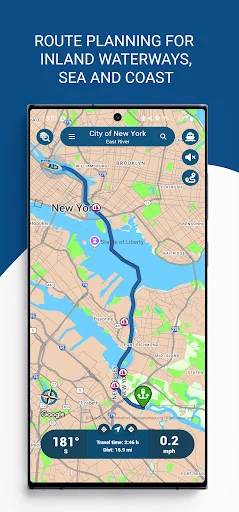
Always on course with NavShip. Travel on more than 580,000 kilometers of waterways across all over the world, especially Europe and North America. Whether inland, sea or coast - with this app you're always on the safe side.
Something for everyone:
Suitable for motorboats, sailing boats and rowing boats, the sailing area can be adapted to all possible types of boat.
Your advantages:
Dock-to-dock route planning, live weather data, wind, tides, clearance heights, marinas, anchorages and ber…
Always on course with NavShip. Travel on more than 580,000 kilometers of waterways across all over the world, especially Europe and North America. Whether inland, sea or coast - with this app you're always on the safe side.
Something for everyone:
Suitable for motorboats, sailing boats and rowing boats, the sailing area can be adapted to all possible types of boat.
Your advantages:
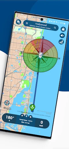
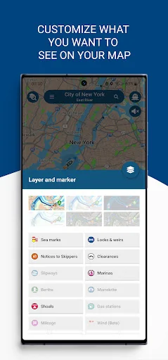
Dock-to-dock route planning, live weather data, wind, tides, clearance heights, marinas, anchorages and berths, inland shipping news, slip ramps, AIS, water levels, water filling stations - from now on you only need one app. NavShip also takes the flow speeds of many bodies of water into account when planning your trip and warns you if it is not possible to travel with your boat.
Note:
This app should only be used as additional support. Please pay attention to your surroundings and follow the usage instructions in the app and on the website. Please note that some rivers and seas may not be included yet. Please use the contact form in the app menu (Report a bug) to request a new waterway and we will implement it as soon as possible.
Free trial:
You can try NavShip for free for 7 full days. We use ads and limit your routes to 40km, or recordings to 8km, unless you purchase a premium version.
Premium:
In-app purchase possible to unlock additional features, e.g. wind and weather data or tide table. We offer subscription packages for one week, one month, three months and one year.
Wear OS:
NavShip offers Wear OS support for smartwatches. You can easily connect the app to live routing, activate this feature in the side menu under "Settings" and "Wear OS support". Calculate a route on your smartphone and see the current speed, course deviation, distance and travel time on the smartwatch.
If you have any questions, criticism or suggestions, you can reach our support around the clock at support@navship.org.
Comparable Android apps
The five apps in Maps & Navigation with the closest revenue to NavShip - Waterway Routing. Click any to see its detail page.
Each forecast combines App Store rating, ratings count, monetisation model, pricing tier, IAP signals and ad-supported flag.
The base estimate is then multiplied by a per-category scaling factor learned from apps with founder-verified MRR.
Every number on this page comes from public APIs and bumetric's own snapshot history.
Full methodology covers input variables, accuracy bands per category and how we treat apps without comparable anchors.
See also the live data on NavShip - Waterway Routing's tracker page for current rating, reviews and snapshot timeline.
Building something similar? Get a free AI audit with $-revenue forecasts for every recommendation.



 Longdo Traffic
 Tainan City Bus
 Naonedbus : Bus, Tram à Nantes
 FLY is FUN Aviation Navigation
 Trizy - O App do motorista