What NZ Topo50 Offline - South actually does (from store listing)
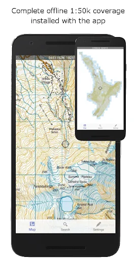
Complete 1:50k offline topographic map coverage using the LINZ NZTopo50 series maps. The maps are included fully with the install. No additional downloads, no account signup, no missing tiles, no added fees, just seamless offline pan and zoom across the whole South Island.
Ideal for back country navigation without cell phone access. Popular with trampers, walkers, bikers, runners, hunters, search and rescue, Te Araroa walkers.
Navigation functions includes GPS positioning, track logging, u…
Complete 1:50k offline topographic map coverage using the LINZ NZTopo50 series maps. The maps are included fully with the install. No additional downloads, no account signup, no missing tiles, no added fees, just seamless offline pan and zoom across the whole South Island.
Ideal for back country navigation without cell phone access. Popular with trampers, walkers, bikers, runners, hunters, search and rescue, Te Araroa walkers.
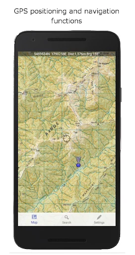
Navigation functions includes GPS positioning, track logging, user waypoints, orientation (compass), altitude and speed display, distance and bearing to points on the map, route creation, route following. Search for and zoom to named places and features on the map. Tracks and waypoints can be imported, exported, and shared in kml or gpx format.
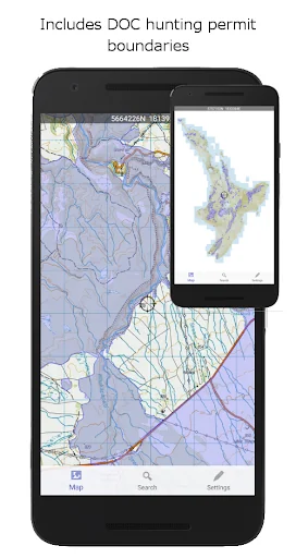
Overlays including DOC open permit hunting boundaries, Te Araroa tracks, and other data is included.
This app is built from the ground up to use the NZ national map grid, not the global average WGS84 datum commonly used which distorts the map. This is easy to spot. A true NZ grid will give you perfectly parallel gridlines when the LINZ map is projected onto it.
No internet or cellular phone connection is needed for full use of all the maps and navigation functions.
The storage space required for this app is reasonably large. Ensure you have sufficient space available.
Made in NZ.
Comparable Android apps
The five apps in Maps & Navigation with the closest revenue to NZ Topo50 Offline - South. Click any to see its detail page.
Each forecast combines App Store rating, ratings count, monetisation model, pricing tier, IAP signals and ad-supported flag.
The base estimate is then multiplied by a per-category scaling factor learned from apps with founder-verified MRR.
Every number on this page comes from public APIs and bumetric's own snapshot history.
Full methodology covers input variables, accuracy bands per category and how we treat apps without comparable anchors.
See also the live data on NZ Topo50 Offline - South's tracker page for current rating, reviews and snapshot timeline.
Building something similar? Get a free AI audit with $-revenue forecasts for every recommendation.

 ContraCam - Speed Cameras, HUD
 Bolt Driver: Drive & Earn
 Cittamobi: Ônibus e Trilhos
 Villages GPS
 Radarbot: Radar Detector, GPS