What OutDoors GPS - Offline OS maps actually does (from store listing)
The #1 Outdoors Navigation App
“The best way to access Ordnance Survey Maps. Five out of Five Stars.” -Stuff Magazine
"Best UK Travel App Winner" –The Telegraph
“The perfect tool for navigating off-road.” –Outdoors Magazine
• Trusted by hikers, cyclists, ramblers, and outdoor instructors.
• OutDoors GPS makes it easy to enjoy the great British countryside in confidence.
• At a fraction of the cost of a dedicated GPS device, spend less time staring at maps and more time stretching your …
“The best way to access Ordnance Survey Maps. Five out of Five Stars.” -Stuff Magazine
"Best UK Travel App Winner" –The Telegraph
“The perfect tool for navigating off-road.” –Outdoors Magazine
• Trusted by hikers, cyclists, ramblers, and outdoor instructors.
• OutDoors GPS makes it easy to enjoy the great British countryside in confidence.
• At a fraction of the cost of a dedicated GPS device, spend less time staring at maps and more time stretching your legs.
• The only outdoors navigation app that combines all your favorite OS maps, with the features you need in a simple interface.
• There is now no reason to ever get lost again. Simply create a route on Ordnance Survey maps..…and go!
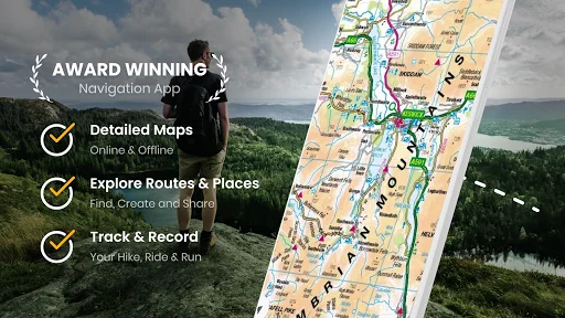
OutDoors GPS takes outdoors navigation to new heights:
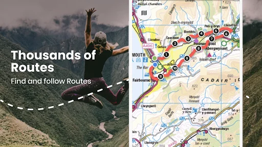
• Hikers: Find or plan a route by choosing from over 200,000 free routes. Then navigate using the built in compass & simple direction view. Track your journey and finally save and share favorite hidden by creating a ‘My Places” list
• Runners: Add variety to your running routes by searching our database of local routes based on distance and elevation. Track your stats & save your favorite places for great views, stretching, resting and water fountains
• Cyclists: Find a route that matches your level of intensity by searching entries by distance and elevation. Or craft your own perfect biking path with the route builder. Use the hands free mode while biking and track your route statistics
• Photographers: Find beautiful landscapes by searching through over 250,000 points of interests. Find or plan your route to get there by using distance markers and confidently explore offline with Satellite, Terrain, Hybrid, and Road maps
EXPLORE CONFIDENTLY
• Dependable anywhere - Break free of phone signals and download maps to use and explore anywhere
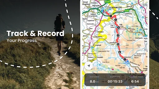
• Find, plan, share, and record routes with statistics & elevation profiles
• 200,000+ Free routes available for route planning on integrated website (outdoorsgps.com)
• Worldwide map coverage with Satellite, Terrain, Hybrid & Road maps
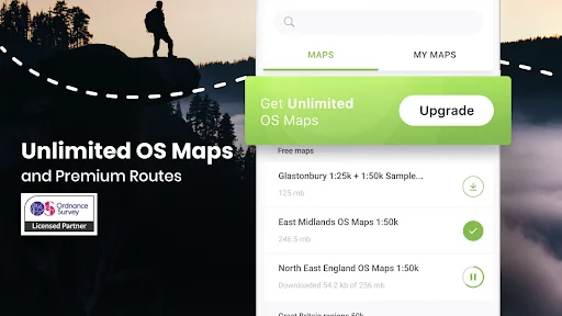
ORDNANCE SURVEY MAPS
• Download any Landranger 1:50k, Explorer 1:25k Ordnance Survey maps (PRO)
• Super fast map display, regardless of signal
POWERFUL GPS FUNCTIONS
• Fully functioning GPS at a fraction of the cost of a dedicated GPS device
• Finds your location in seconds- accurate to within 10 metres
• Create a route, with distance markers, by tapping it out on the screen
• Follow a planned route using the in-built compass & clear direction view
• Hands Free mode (for following a route while cycling)
• Create and Share 'My Places' list (favourite pub, picnic area, great view etc)
• 250,000 points of interest included (with fast search tool)
WEBSITE & ONLINE COMMUNITY (100,000+ MEMBERS)
• Do all your planning (or post trip analysis) with OS maps.
• Plan, edit and share your routes (via Email, Twitter or Facebook).
You can subscribe to unlimited OS maps with OutDoors PRO. Your yearly subscription will be £30 from the date of subscription and will automatically renew unless cancelled at least 24 hours before the end of the current period. Auto-renew can be turned off anytime after purchase. No cancellation of the current subscription is allowed during active subscription period. Also access OS maps on our website: http://outdoorsgps.com
Note: Continued use of GPS running in the background can dramatically decrease battery life.
Terms of Use: http://outdoorsgps.com/terms
Privacy Policy: http://outdoorsgps.com/privacy
Comparable Android apps
The five apps in Travel & Local with the closest revenue to OutDoors GPS - Offline OS maps. Click any to see its detail page.
Each forecast combines App Store rating, ratings count, monetisation model, pricing tier, IAP signals and ad-supported flag.
The base estimate is then multiplied by a per-category scaling factor learned from apps with founder-verified MRR.
Every number on this page comes from public APIs and bumetric's own snapshot history.
Full methodology covers input variables, accuracy bands per category and how we treat apps without comparable anchors.
See also the live data on OutDoors GPS - Offline OS maps's tracker page for current rating, reviews and snapshot timeline.
Building something similar? Get a free AI audit with $-revenue forecasts for every recommendation.

 Cocobuk - Prenota il tuo posto
 Berlin Guide by Civitatis
 ANC Explorer
 fonaCAB
 AKT Reise