How much does PeakVisor - 3D Maps & Peaks ID earn?
Android app
from Routes Software SRL
· Travel & Local
ML forecast★ 3.8 · 1KFree
~3.9K/mo
ML revenue forecast.
Calibrated against 30046 apps in this category.
Confidence band
±15%
High — many comparable apps with verified data
At a glance
Earns 25.31× more than the category median (155/mo).
Ranks #298 of 30,046 in Travel & Local (top 1.0% by revenue).
Launched Jun 14, 2017 · last updated May 27, 2026.
What the app looks like
Live screenshots from the Play Store, captured by our snapshot worker. Tap any image to enlarge.
PeakVisor - 3D Maps & Peaks ID's revenue trajectory
Forecast revenue from snapshot history. Last 1 months.
Where PeakVisor - 3D Maps & Peaks ID sits in Travel & Local
Revenue distribution of 30046 comparable apps. PeakVisor - 3D Maps & Peaks ID highlighted.
PeakVisor - 3D Maps & Peaks ID vs comparable apps
Revenue trajectory side-by-side. Bold = PeakVisor - 3D Maps & Peaks ID, ghosted = peers.
App spec
Version
2.9.80
Last update
May 27, 2026
Launched
Jun 14, 2017
Price
Free
Monetization
Free
What PeakVisor - 3D Maps & Peaks ID actually does (from store listing)
PeakVisor will make you a champion of mountain navigation, putting state-of-the-art Peak Identification, 3D Maps, Trails, and outdoor GPS tracking into the palm of your hand. Our app is a one-stop shop for all your mountain adventures: hiking, skiing, climbing, mountain biking, and more. But PeakVisor is more than just another outdoors app; it’s an immersion into a carefully crafted 3D world that will give you an unprecedented understanding of the nuances of a mountain’s terrain.
Here’s a bri…
PeakVisor will make you a champion of mountain navigation, putting state-of-the-art Peak Identification, 3D Maps, Trails, and outdoor GPS tracking into the palm of your hand. Our app is a one-stop shop for all your mountain adventures: hiking, skiing, climbing, mountain biking, and more. But PeakVisor is more than just another outdoors app; it’s an immersion into a carefully crafted 3D world that will give you an unprecedented understanding of the nuances of a mountain’s terrain.
Here’s a brief orientation on the tools we offer to get oriented in the mountains:
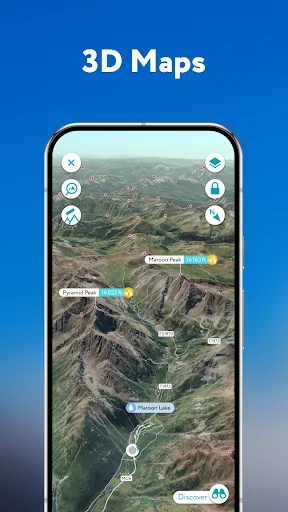
● 3D Maps
As human athletic achievement progresses in the mountains, so does the technology to assist your adventures. With PeakVisor, you unlock the topo maps of the future; our cutting-edge technology with high-precision terrain modeling offers deep insight into the mountain landscape of your choice. With one glance, you be blessed with years of knowledge about an area’s terrain.
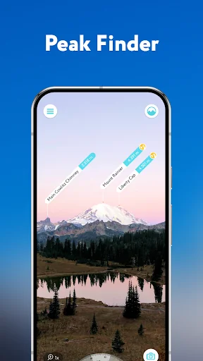
● Identify Peaks
Identify more than a million mountains, hills, buttes, spires, and more from all over the world, with a detailed profile for each of them! Our app shows you altitude, topographic prominence, mountain range, national parks or reserves, as well as photos and additional Wikipedia articles.
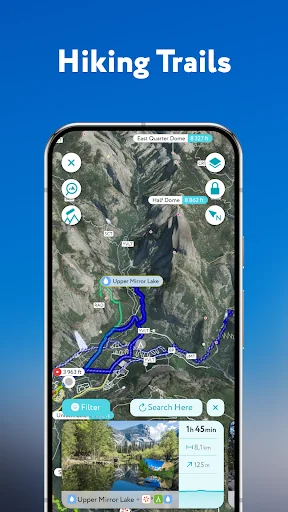
● Plan Hiking Routes
A vast network of worldwide hiking trails and walking pathways included in PeakVisor’s 3D Maps will help you compose a hiking route which includes evaluating the distance you can expect to hike as well as a route’s elevation profile and estimated time for completion.
● Skiing
In winter mountain sports, PeakVisor’s topographic 3D Maps allow a visual understanding of the terrain and provide detailed information about mountain lifts, ski resort trails, and backcountry ski touring routes. The app also offers features such as winter mode and a slope steepness overlay to identify avalanche terrain on your route.
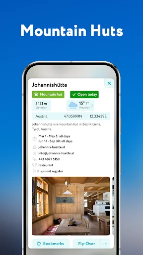
● Cable Cars and Mountain Huts are inlaid onto our 3D Maps, complete with schedules. This is especially useful in Europe, where many objectives involve a cable car ride to gain some altitude, lest you want to do some genuinely punishing climbs. And you haven’t experienced the old-world mountain culture until you’ve had a memorable meal and night at a rustic mountain hut in the high country.
● Peak Bagging
The app offers monthly climbing challenges and Peak Bagging competitions to keep the motivation where it needs to be…UP.
● GPS Tracking
Track any outdoor adventures, whether hiking, skiing, mountain biking, etc. Post-adventure, you can visualize your route in the miniature 3D world, check out stats like distance and elevation gain, and export a GPX file of your new route.
● All Features Work Offline
PeakVisor is the Swiss army knife for outdoor adventure, one that you will soon find indispensable while in the mountains. With so many features at your fingertips, you’ll find value from the app whenever you're on the trail.
Comparable Android apps
The five apps in Travel & Local with the closest revenue to PeakVisor - 3D Maps & Peaks ID. Click any to see its detail page.
Each forecast combines App Store rating, ratings count, monetisation model, pricing tier, IAP signals and ad-supported flag.
The base estimate is then multiplied by a per-category scaling factor learned from apps with founder-verified MRR.
Every number on this page comes from public APIs and Bumetric's own snapshot history.
Full methodology covers input variables, accuracy bands per category and how we treat apps without comparable anchors.
See also the live data on PeakVisor - 3D Maps & Peaks ID's tracker page for current rating, reviews and snapshot timeline.
Building something similar? Get a free AI audit with $-revenue forecasts for every recommendation.


 Alhambra & Generalife Granada
 Gylis
Gylis
 Google Earth
 Fly Delta
 Marriott Bonvoy: Book Hotels