What RunwayMap: Aviation Weather actually does (from store listing)
RunwayMap is the #1 pilot community all about the passion of flying. You can view flight videos, reviews and photos from other pilots as well as share your flying experiences.
The interactive map gives you an overview of the airports. We have collected important information on every airport:
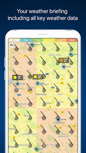
• Aviation weather forecasts
• Runways & NOTAM
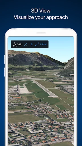
• 3D and satellite views
• Webcams and much more
RunwayMap simplifies flight preparation and complements flight planning tools such as ForeFlight, J…
RunwayMap is the #1 pilot community all about the passion of flying. You can view flight videos, reviews and photos from other pilots as well as share your flying experiences.
The interactive map gives you an overview of the airports. We have collected important information on every airport:
• Aviation weather forecasts
• Runways & NOTAM
• 3D and satellite views
• Webcams and much more
RunwayMap simplifies flight preparation and complements flight planning tools such as ForeFlight, Jeppesen and Garmin Pilot.
Download the versatile pilot app while you are at it.
Features:
MAP
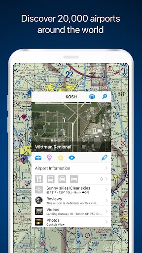
Search by name or ICAO to discover new airports. Receive important information such as the current weather, address, position, runways, and sunrise/sunset. Mark and save what airports you’ve already flown to or those you’d like to fly to next. Save your personal notes for every airport.
AVIATION WEATHER
Current weather reports, visual flight conditions und wind forecasts are shown on our map.
ON-SITE SERVICES
Discover restaurants and hotels near the airport. Get informed about public transport and car rental offers.
3D AND SATELLITE VIEWS
Check out the airport environment in 3D and satellite views. Use the OpenStreetMap view for detailed vehicle access information.
DOCUMENTS
With just a few clicks, add your flight documents, such as the Jeppesen approach charts, FAA terminal procedures and airport diagrams, Foreflight manuals or the Garmin pilot’s guide. That way you always have them close at hand.
TOOLS
Use the handy calculator for conversions for distance, weight, temperature, and more. Have it display your QNH and QFE.
RUNWAYMAP APP
Important note: RunwayMap is not intended to provide aeronautical information or navigation aids. For navigation purposes, we strongly recommend using only approved and updated aviation information such as ForeFlight, Jeppesen or Garmin Pilot.
The weather data shown in RunwayMap is only general information about possible weather development. It does not replace professional weather briefing by an official body before the flight.
Learn more about RunwayMap at runwaymap.com
Comparable Android apps
The five apps in Weather with the closest revenue to RunwayMap: Aviation Weather. Click any to see its detail page.
Each forecast combines App Store rating, ratings count, monetisation model, pricing tier, IAP signals and ad-supported flag.
The base estimate is then multiplied by a per-category scaling factor learned from apps with founder-verified MRR.
Every number on this page comes from public APIs and bumetric's own snapshot history.
Full methodology covers input variables, accuracy bands per category and how we treat apps without comparable anchors.
See also the live data on RunwayMap: Aviation Weather's tracker page for current rating, reviews and snapshot timeline.
Building something similar? Get a free AI audit with $-revenue forecasts for every recommendation.


 WQOW 18 StormTrack
 umweltinfo
 FOX13 Weather
 WEEK 25 First Alert Weather
 Live Air by Kaiterra: Global A