What ShipAtlas - Vessel Tracker actually does (from store listing)
Live AIS ship tracking at your fingertips
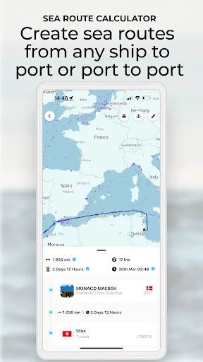
Track vessels and port traffic in real time, monitor areas, and create sea routes from port to port or estimate the ETA for any of the vessels' live position to any ports. Cross platform (mobile phone and desktop)!
Whether you're a shipping enthusiast or a professional, have family at sea, or are just curious about the vessels sailing nearby you, ShipAtlas gives you the tools you need to explore and track vessels.
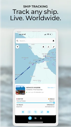
See live vessel positions arou…
Track vessels and port traffic in real time, monitor areas, and create sea routes from port to port or estimate the ETA for any of the vessels' live position to any ports. Cross platform (mobile phone and desktop)!
Whether you're a shipping enthusiast or a professional, have family at sea, or are just curious about the vessels sailing nearby you, ShipAtlas gives you the tools you need to explore and track vessels.
See live vessel positions around the world, search for vessels, explore ports, and get insights of vessels movements and port traffic with raw AIS data from more than 700 satellites, terrestrial sources, and dynamic AIS data. More than 125,000 vessels. Any type of vessel. Global coverage.
Key Features:
- Worldwide live AIS ship tracking for any type of vessel: containers, car carriers, cruise ships, tankers, dry cargo, LPG, LNG, oil service etc. Search by name, IMO, or MMSI.
- View a ship’s last and next port to see where it has been and where it’s headed (includes historical data for the last 3 port calls).
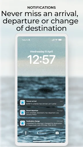
- Get notifications when vessels arrive or depart from ports, or when they set or change their destination.
- Create sea routes from any AIS position to any port and estimate arrival times based on various speeds.
- Access daily updated maritime weather forecasts, including wind, waves, ocean currents, sea ice, and precipitation.
Explore maritime activity worldwide. From your phone, tablet or laptop, you can view global shipping activity, locate vessels, and check ship statuses at sea.
Why ShipAtlas?
- High quality AIS and maritime data for ports and any type of vessels.
- Clean and easy-to-use interface.
- Sync your data across mobile, desktop, and tablet.
- Be notified about real-time events for vessels and ports.
- Friendly in-app chat support to assist you any time you need help.
- Free Trial - Test the app for free before upgrading
- No ads.
- Trusted by casual ship trackers and maritime professionals around the world.
Find a plan for your needs
Standard – from €10/month
Unlock for 5 vessels:
- Live ship positions from satellite, terrestrial and dynamic AIS.
- Find which port the vessels sailed from and the next port with ETA.
Each forecast combines App Store rating, ratings count, monetisation model, pricing tier, IAP signals and ad-supported flag.
The base estimate is then multiplied by a per-category scaling factor learned from apps with founder-verified MRR.
Every number on this page comes from public APIs and bumetric's own snapshot history.
Full methodology covers input variables, accuracy bands per category and how we treat apps without comparable anchors.
See also the live data on ShipAtlas - Vessel Tracker's tracker page for current rating, reviews and snapshot timeline.
Building something similar? Get a free AI audit with $-revenue forecasts for every recommendation.

 Warehouse Management
 OpenRoaming
 Budget Manager
 Really.ToDo: To do list, notes
 Viet Nam Pepper App - IPC