ML revenue forecast.
Calibrated against 77129 apps in this category.
Confidence band
±15%
High — many comparable apps with verified data
At a glance
Earns 2.48× more than the category median (189/mo).
Ranks #12,300 of 77,129 in Tools (top 15.9% by revenue).
Launched Jul 30, 2016 · last updated Nov 01, 2023.
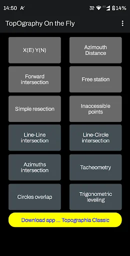
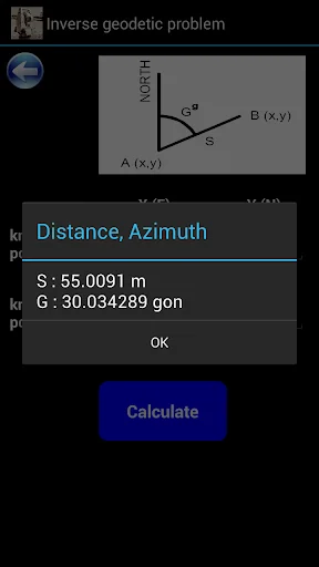
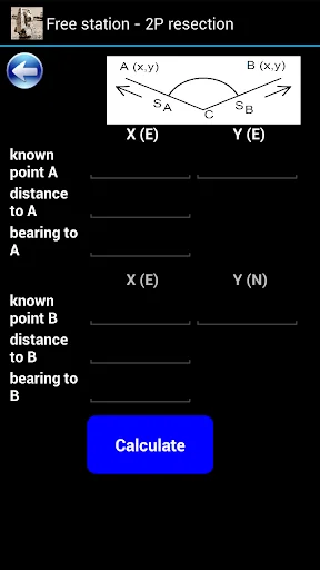
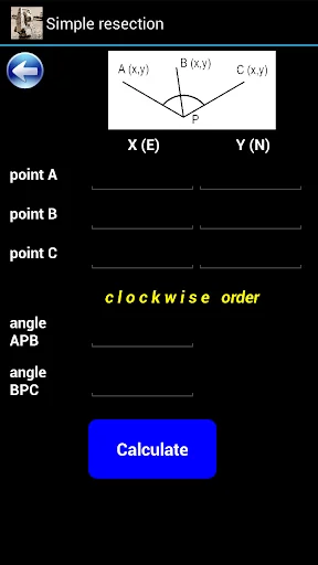
What the app looks like
Live screenshots from the Play Store, captured by our snapshot worker. Tap any image to enlarge.
Topography On the Fly's revenue trajectory
Forecast revenue from snapshot history. Last 1 months.
Where Topography On the Fly sits in Tools
Revenue distribution of 77129 comparable apps. Topography On the Fly highlighted.
Topography On the Fly vs comparable apps
Revenue trajectory side-by-side. Bold = Topography On the Fly, ghosted = peers.
App spec
Version
9.07.12
Last update
Nov 01, 2023
Launched
Jul 30, 2016
Price
Free
Monetization
Free
What Topography On the Fly actually does (from store listing)
Topography On the Fly is a suite of land surveying tools. It allows you to have complex surveying calculations on the field quickly with maximum accuracy. The design is as simple as needed under work pressure. The advantage is that can be used only with a simple total station or additionally with more complex instruments and gps.
Angular units : gradians (default) and decimal degrees (degrees only in Distance/Azimuth).
Task list:
Direct geodetic problem
Inverse geodetic problem
Simple …
Topography On the Fly is a suite of land surveying tools. It allows you to have complex surveying calculations on the field quickly with maximum accuracy. The design is as simple as needed under work pressure. The advantage is that can be used only with a simple total station or additionally with more complex instruments and gps.
Angular units : gradians (default) and decimal degrees (degrees only in Distance/Azimuth).
Task list:
Direct geodetic problem
Inverse geodetic problem
Simple forward intersection
Two points resection – Free station
Simple resection
Inaccessible points
Line-line intersection
Line-circle intersection
Azimuths intersection
Tacheometry
Circles overlap
Trigonometric leveling
Great tool for land surveyors, civil engineers, topographers and land engineers.
Download also our free application:
"Geodetic NET" from Google play
https://play.google.com/store/apps/details?id=com.GeodeticNET&hl=en
"Surveying In the Field" from Google play
https://play.google.com/store/apps/details?id=com.Surveying.IntheField&hl=en
"Topographia Classic" from Google play
https://play.google.com/store/apps/details?id=com.Topographia.Classic&hl=en&gl=US
Don't forget to rate this app and send us a feedback.
Comparable Android apps
The five apps in Tools with the closest revenue to Topography On the Fly. Click any to see its detail page.
Each forecast combines App Store rating, ratings count, monetisation model, pricing tier, IAP signals and ad-supported flag.
The base estimate is then multiplied by a per-category scaling factor learned from apps with founder-verified MRR.
Every number on this page comes from public APIs and bumetric's own snapshot history.
Full methodology covers input variables, accuracy bands per category and how we treat apps without comparable anchors.
See also the live data on Topography On the Fly's tracker page for current rating, reviews and snapshot timeline.
Building something similar? Get a free AI audit with $-revenue forecasts for every recommendation.

 Mit Telenor, Danmark
 Air-Share
 Cow Master - Herd Management
 Sms Doodle Keyboard Theme
 Lens Cap - Disable Camera