ML revenue forecast.
Calibrated against 2454 apps in this category.
Confidence band
±15%
High — many comparable apps with verified data
At a glance
Earns 7.9× more than the category median (849/mo).
Ranks #147 of 2,454 in Travel (top 6.0% by revenue).
Launched Apr 11, 2014 · last updated Apr 01, 2026.
24 months of snapshot history tracked.
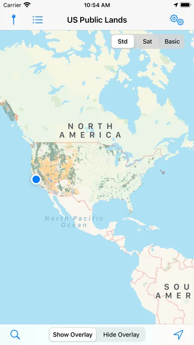
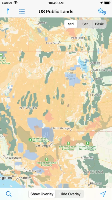
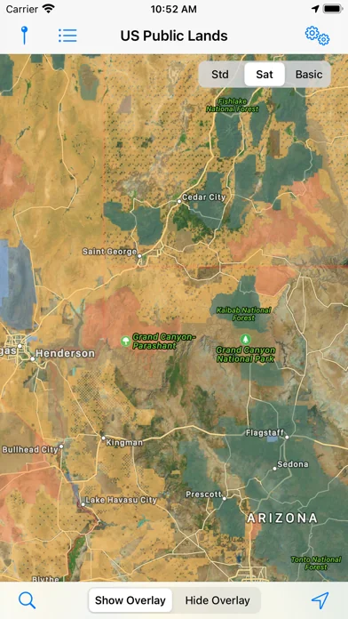
What the app looks like
Live screenshots from the App Store, captured by our snapshot worker. Tap any image to enlarge.
US Public Lands's revenue trajectory
Forecast revenue from snapshot history. Last 24 months.
Where US Public Lands sits in Travel
Revenue distribution of 2454 comparable apps. US Public Lands highlighted.
US Public Lands vs comparable apps
Revenue trajectory side-by-side. Bold = US Public Lands, ghosted = peers.
App spec
Version
2026.3
Last update
Apr 01, 2026
Launched
Apr 11, 2014
Min OS
15.6
Rating
4+
Price
Free
Monetization
Paid
Languages
EN
What US Public Lands actually does (from App Store listing)
The US Federal Governments owns nearly 650 million acres of land - almost 30 percent of the land area of the United States.
These are lands that are held for all Americans.
US Public Lands allows you to quickly retrieve the boundaries of these properties without carrying physical maps, books, or digging deep online.
Included in the app are on-device (fully works offline), individually selectable & beautifully colored map layers for most of the properties administered by the federal government…
The US Federal Governments owns nearly 650 million acres of land - almost 30 percent of the land area of the United States.
These are lands that are held for all Americans.
US Public Lands allows you to quickly retrieve the boundaries of these properties without carrying physical maps, books, or digging deep online.
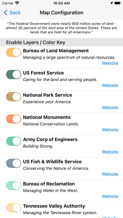
Included in the app are on-device (fully works offline), individually selectable & beautifully colored map layers for most of the properties administered by the federal government:
- Bureau of Land Management (BLM) - US Forest Service (FS) - National Park Service (NPS) - Army Corp of Engineers (ACOE) - US Fish & Wildlife Service - Bureau of Reclamation - Tennessee Valley Authority - Department of Defense (military bases & installations) - Other (National Laboratories, Test Sites, etc...)
Key Benefits & Features
- Know which US agency owns and operates the land you're on or are heading to. Use the "Layers" icon to select which agencies you want displayed to create your own custom map. (Hint, the toggles are color coded to the color each layer is displayed in.)
- Links are provided to each agency's website within the app, so that you can further your research as to what land use rules apply for each public land type - such as permits, fees, activities allowed, and limits of stay.
- Map layers are stored on device - no internet connection required.
- Be sure to turn on the 'Basic' base map to see the US Public Land labels for each land area. This base map layer is also stored entirely on your device, and can be utilized if you do not have an internet connection or would like to conserve bandwidth.
- If you have an internet connection (or have cached them before going out of signal), you can utilize the built in Apple Maps and satellite view maps as the base layer underneath the public land overlays.
- A boondocker's assistant - While US Public Lands is not specifically a camp site locator and does not have a database of specific sites, by turning on the satellite view map, you can better scout out trails, roads and signs of dispersed camping locations within the boundaries of the public land resources.
- Quickly toggle between 'Show' and 'Hide' via the "Map" icon to more clearly see satellite images below.
- If you have GPS access on your device, click the 'Locate Me' icon to show your present location - know what type of land you're on right now!
- Built in search tool locates anything on device maps supports (requires internet access) - including cities, states, zip codes, addresses and points of interest. A pin is dropped at the search location.
Thank you to the Protected Area Database (PAD-US) of the U.S. Geological Survey for providing the public domain raw map data that we’ve been able to utilize to create this interactive overlayable mapping & navigation tool. We will update our maps in the future to stay in sync with improvements to this data set.
Please note, the USGS PAD-US database contains the “most up-to-date aggregation of Federal lands and waters” available, but this database is still evolving and some locations may not be listed and others may not have precisely accurate boundaries. Resolution across the nation may vary. And always remember - there may be private unmapped inholdings within any public lands - so always pay attention to local signage, indications, and information.
The US Public Lands app should only be used as an overview, and you should always confirm more precise details by consulting local field offices, administration websites, and other resources. Do not solely rely on this app for determining if you are on public or private land.
🆕 What's new · v2026.3
Updated maps to PADUS 4.1
Added ability to backup and restore pins.
Added export feature so that pins can be imported into mapping software.
Comparable iOS apps
The five apps in Travel with the closest revenue to US Public Lands. Click any to see its detail page.
Each forecast combines App Store rating, ratings count, monetisation model, pricing tier, IAP signals and ad-supported flag.
The base estimate is then multiplied by a per-category scaling factor learned from apps with founder-verified MRR.
Every number on this page comes from public APIs and bumetric's own snapshot history.
Full methodology covers input variables, accuracy bands per category and how we treat apps without comparable anchors.
See also the live data on US Public Lands's tracker page for current rating, reviews and snapshot timeline.
Building something similar? Get a free AI audit with $-revenue forecasts for every recommendation.

 BZ-Lieblingsplätze: Ausflüge
 CampingCard ACSI
 French by Nemo
 GPSmyCity: Walks in 1K+ Cities
 Big Island Hawaii Gypsy Guide