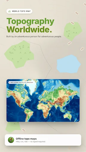
What World Topo Map actually does (from store listing)
Topographic map of the world with <b>no</b> limitations:
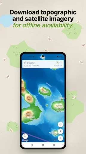
• View and cache topographic tiles and satellite imagery
• Download topographic tiles in a visible region and below (for offline availability)
• Add unlimited map markers
• Import GPX / KML / FIT waypoints, tracks and routes
• Import and create GeoJSON areas
• Plan, create and edit tracks with a powerful GPX editor
• Record routes or follow imported tracks
• Export or share markers, tracks and areas
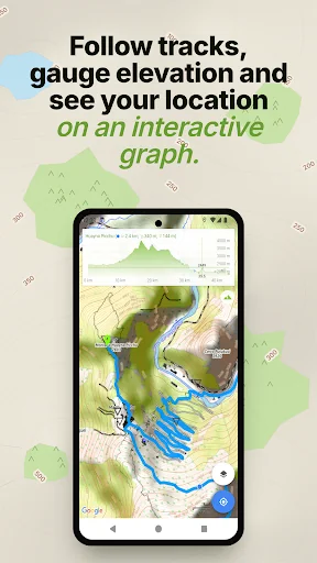
• View track / route elevatio…
• View and cache topographic tiles and satellite imagery
• Download topographic tiles in a visible region and below (for offline availability)
• Add unlimited map markers
• Import GPX / KML / FIT waypoints, tracks and routes
• Import and create GeoJSON areas
• Plan, create and edit tracks with a powerful GPX editor
• Record routes or follow imported tracks
• Export or share markers, tracks and areas
• View track / route elevation profile (with interactive graph)
• View distance, ascent, descent, moving time and speed information
• Measure distance (in a straight line) between multiple points and markers
• Search for places of interest (supports Decimal, DMS, MGRS and UTM coordinates)
• Group markers by tag for easy organisation (change colours, toggle visibility)
• Battery conscious (for those that can't recharge every day)
• Space conscious (for those that don't have gigabytes to spare; external SD card support; full tile cache control)
• Stay up-to-date with the latest imagery (no dependency on application updates)
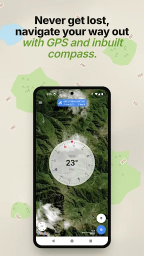
• Navigate with Google Maps interactions (pinch zoom, scroll, rotate, drop marker, drag marker etc)
• Fully functional for free!
World Topo Map is intended for outdoor enthusiasts who want to mark locations visited, create markers to visit, follow imported tracks or create their own. It's designed to be lightweight, intuitive, responsive, battery conscious and totally free. Perfect for casual day trips to serious bush excursions.
Developed by an adventurous person for adventurous people!
Topographic Map Tiles
OpenTopoMap is a free, topographic map generated from the data in the OpenStreetMap and SRTM elevation data.
This service provides excellent topographic coverage of most of the globe, however there may be areas and zoom levels with no topographic information.
World Topo Map uses Google Analytics to anonymously send application metrics to measure stability of the app. No personal information is sent, used or disclosed.
For further information about Google Analytics, see http://www.google.com/analytics. For details of the Google Analytics Privacy Policy see http://www.google.com/policies/privacy
You can opt out of Google Analytics anytime under the Settings menu.
Comparable Android apps
The five apps in Maps & Navigation with the closest revenue to World Topo Map. Click any to see its detail page.
Each forecast combines App Store rating, ratings count, monetisation model, pricing tier, IAP signals and ad-supported flag.
The base estimate is then multiplied by a per-category scaling factor learned from apps with founder-verified MRR.
Every number on this page comes from public APIs and bumetric's own snapshot history.
Full methodology covers input variables, accuracy bands per category and how we treat apps without comparable anchors.
See also the live data on World Topo Map's tracker page for current rating, reviews and snapshot timeline.
Building something similar? Get a free AI audit with $-revenue forecasts for every recommendation.

 Oise Mobilité
 Indigo Neo - Your Parking App
 Circuit électrique
 VVW Fahrpläne & Tickets
 Moovecar