How much does Acres: Land Data & Parcel Maps earn?
iOS app
from AcreMaps, LLC
· Business
ML forecast★ 4.6 · 2K→ StablePaid
~8.3K/mo
ML revenue forecast.
Calibrated against 2625 apps in this category.
Confidence band
±15%
High — many comparable apps with verified data
At a glance
Earns 10.29× more than the category median (802/mo).
Ranks #235 of 2,625 in Business (top 9.0% by revenue).
Launched Oct 04, 2022 · last updated Jun 18, 2026.
24 months of snapshot history tracked.
What the app looks like
Live screenshots from the App Store, captured by our snapshot worker. Tap any image to enlarge.
Acres: Land Data & Parcel Maps's revenue trajectory
Forecast revenue from snapshot history. Last 24 months.
Where Acres: Land Data & Parcel Maps sits in Business
Revenue distribution of 2625 comparable apps. Acres: Land Data & Parcel Maps highlighted.
Acres: Land Data & Parcel Maps vs comparable apps
Revenue trajectory side-by-side. Bold = Acres: Land Data & Parcel Maps, ghosted = peers.
App spec
Version
3.5.9
Last update
Jun 18, 2026
Launched
Oct 04, 2022
Min OS
15.1
Rating
17+
Price
Free
Monetization
Paid
Languages
EN
What Acres: Land Data & Parcel Maps actually does (from App Store listing)
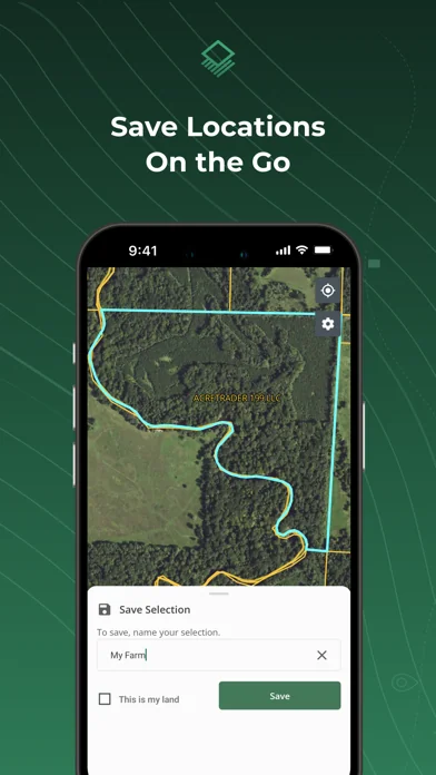
Acres makes discovering property lines, landowner information, and land for sale easier than ever. Now with route tracking, offline maps, 3D maps, waypoints, and custom maps that sync between your mobile device and desktop.
Acres is the ultimate on-the-go mapping and land analysis tool for landowners, developers, land investors, and real estate professionals. Effortlessly locate property boundaries, evaluate parcel-level insights, and browse land listings. With Acres, you’ll have access to data…
Acres makes discovering property lines, landowner information, and land for sale easier than ever. Now with route tracking, offline maps, 3D maps, waypoints, and custom maps that sync between your mobile device and desktop.
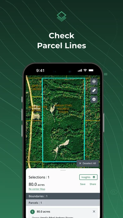
Acres is the ultimate on-the-go mapping and land analysis tool for landowners, developers, land investors, and real estate professionals. Effortlessly locate property boundaries, evaluate parcel-level insights, and browse land listings. With Acres, you’ll have access to data for millions of parcels across the US—plus the power to save and share your property maps on the go.
◆ NEW FEATURE HIGHLIGHTS • Route Tracking: Track and save your path as you walk. • Offline Maps: Access saved satellite-view areas or custom maps when you’re off grid. • 3D Maps: Visualize terrain in 3D mode. • Waypoints: Mark, save, and share points of interest on the map.
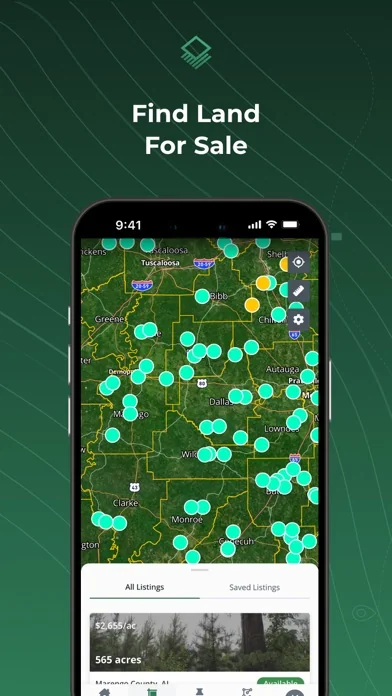
◆ SEARCH LAND FOR SALE • Land Listings: Instantly find and share land for sale across the US.
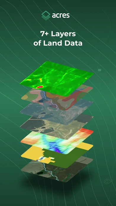
◆ RESEARCH LAND ON THE GO • Soil Maps: Assess soil composition and quality. • Elevation & Topography: Quickly view topographic data with adjustable contour lines. • Historical Imagery: Historic satellite imagery at the parcel level. • Vegetation Index: Historic plant health based on light wave reflection.. • Crop History: Annual crop coverage gathered via satellite imagery. • County Rent: Estimates for cash rental rates for cropland and pastureland. • County Yield: Farmer-reported survey data of annual expected crop yields. • Property Tax: Stay informed with recent property tax info. • Flood and Wetlands: Check flood risk and identify wetland areas.
◆ ACCESS & SHARE LAND DATA ANYWHERE • Save Parcels: Keep track of parcels for offline viewing. • Share Maps: Share your property map and land data directly from the app. • Waypoints: Mark, save, and share points on the map. • Sync with Desktop: Seamlessly move between your mobile device and desktop for full-scale analysis. • Free 3D Maps: Toggle on/off to explore land from every angle—fully compatible with insights and custom maps.
◆ CUSTOM MAPS • Geotag Photos: Snap pictures on-site and automatically mark their location. • Add Notes: Label and add descriptions to your map customizations. • Points of Interest: Mark buildings, hunt stands, and other points of interest. • Save & Sync: Access your custom maps seamlessly across mobile and desktop. • Offline Access: Download your maps before heading out for offline use.
◆ ROUTE TRACKING • Track Every Step: Measure distance, elevation changes, and more as you walk. • Save Your Route: Save your route for later use.
◆ NO ADS
◆ FEEDBACK & SUPPORT We’re always here to help. Send feature requests or get assistance from our team at: support@acres.com.
---
Subscriptions will be charged to your credit card through your iTunes account. Subscriptions will automatically renew unless canceled at least 24 hours before the end of the current period. Subscriptions can be managed and canceled at any time through your iTunes account settings. If you cancel during the subscription term, you will not receive a refund of subscription fees for that term. Any unused portion of a free trial will be forfeited. For more details, please review our www.acres.com/terms-of-use and www.acres.com/privacy-policy.
Each forecast combines App Store rating, ratings count, monetisation model, pricing tier, IAP signals and ad-supported flag.
The base estimate is then multiplied by a per-category scaling factor learned from apps with founder-verified MRR.
Every number on this page comes from public APIs and bumetric's own snapshot history.
Full methodology covers input variables, accuracy bands per category and how we treat apps without comparable anchors.
See also the live data on Acres: Land Data & Parcel Maps's tracker page for current rating, reviews and snapshot timeline.
Building something similar? Get a free AI audit with $-revenue forecasts for every recommendation.

 ChatGPT
 Invoice Maker App -InvoiceBase
 Duolingo: Language Lessons
 Eco Kat App
 Call Recorder App ◉ACR MyCalls