Live screenshots from the Play Store, captured by our snapshot worker. Tap any image to enlarge.
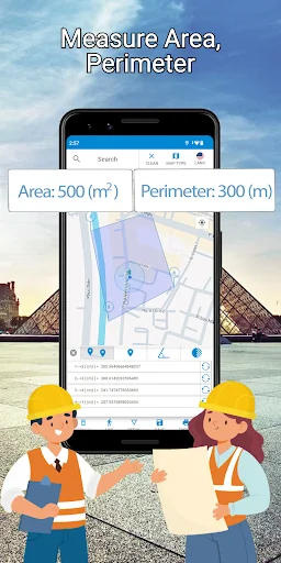
📏 Area Calculator for Land – Field, Perimeter, and Distance Measurement Tool
The ultimate land measurement tool for farmers, surveyors, real estate agents, and construction professionals. Whether you're measuring a field, calculating acreage, estimating the size of a property, or tracking your walking route, this app provides fast and accurate results directly on Google Maps™.
🔍 Key Features:
Measure area, distance, perimeter, and square footage on any type of land.
Draw property boundar…
Read full description →
📏 Area Calculator for Land – Field, Perimeter, and Distance Measurement Tool
The ultimate land measurement tool for farmers, surveyors, real estate agents, and construction professionals. Whether you're measuring a field, calculating acreage, estimating the size of a property, or tracking your walking route, this app provides fast and accurate results directly on Google Maps™.
🔍 Key Features:
Measure area, distance, perimeter, and square footage on any type of land.
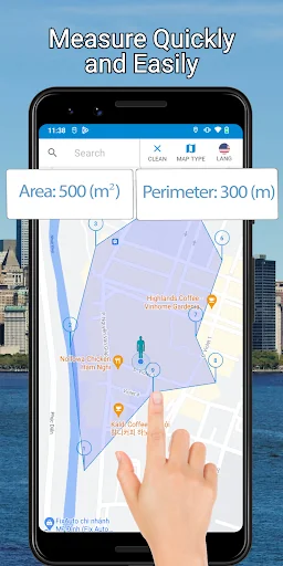
Draw property boundaries or custom polygons by simply tapping on the map.
Use real-time GPS tracking for walking surveys, route tracking, or mobile fieldwork.
Switch easily between map types: normal, satellite, hybrid, terrain, or none.
Measure land, construction sites, farms, gardens, or any real estate properties.
Export or save your data with high accuracy and detailed metadata (coming KML format support).
View and manage multiple measurement units: meters, feet, acres, hectares, square kilometers, etc.
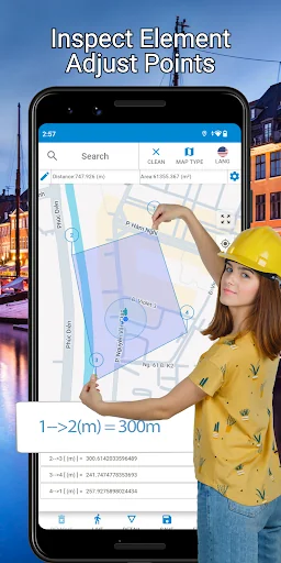
Resize and edit any defined area or shape by dragging points on the map.
Supports offline caching for areas you’ve already measured.
Ideal for daily surveys, site planning, farming, and land inspection tasks.
🧭 How It Works:
Tap the “Add Point” icon, then tap on the map to place measurement points using latitude & longitude.
Define multiple points to automatically calculate area, perimeter, distance, and shape details.
Click “Polyline” for a virtual walk-through of your plotted route.
Use the “Live” icon to start real-time tracking with GPS while walking around the land.
Tap “Remove” to delete individual points or “Clear” to reset everything.
Save your current map data for later use or share it with colleagues.
🌐 Designed For:
Land surveyors measuring plots, properties, and development zones.
Farmers calculating acreage or field layout.
Real estate agents estimating and visualizing property boundaries.
Construction teams needing site measurement or land prep.
Anyone needing fast and reliable field measurement tools.
🔧 Technical Notes:
Uses Google Maps™ and the latest GPS & location services for high-precision calculations.
For best results, ensure GPS High Accuracy Mode is active and network connectivity is stable.
If your position jumps randomly, recalibrate GPS or avoid indoor measurement.
📬 Support & Feedback:
Encounter issues or have suggestions? Email us at:
📩 clstudio.info.applications@gmail.com
Please include screenshots and describe the issue clearly. We’re committed to fixing bugs and improving your experience.
- Facebook :
https://www.facebook.com/Area-Calculator-For-Land-Perimeter-and-Field-108007074317220/
- Youtube :
https://www.youtube.com/channel/UCPfi4XeYX6MF6wQ84JbBVPA/
- Website :
https://clstudio.info/areacalculator/index.html
The five apps in Maps & Navigation with the closest revenue to Area Calculator For Land. Click any to see its detail page.
Each forecast combines App Store rating, ratings count, monetisation model, pricing tier, IAP signals and ad-supported flag.
The base estimate is then multiplied by a per-category scaling factor learned from apps with founder-verified MRR.
Every number on this page comes from public APIs and bumetric's own snapshot history.


 Earth Camera: Satellite View
 JustPark Parking
 mappy (맵피)
 TruckPad: Cargas e Fretes
 NaviExpert - Nawigacja i Mapa